Subject: United States, Texas, Mexico
Period: 1846 (circa)
Publication: Mitchell's School and Family Geography
Color: Hand Color
Size:
16.8 x 10.5 inches
42.7 x 26.7 cm
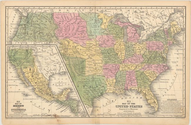
This map has terrific western territorial borders including a large Texas with stovepipe border extending well above Pike's Peak to the 42nd parallel. Austin is shown as the state capital in the map and the republic's capital in the inset map, so it was likely produced in the transitional mid-1840s. It names Bexar, Victoria, Columbia, Houston, Franklin, and Galveston. Notations within Texas include "Herds of Buffaloes and Wild Horses," "Mustang Desert," and "Extensive Prairies." The Great American Desert extends from the panhandle up into the large Indian Territory. The huge Missouri Territory lays between the even larger Oregon Territory and extends to meet an unnamed territory attached to Iowa at the Missouri River. The large Indian Territory fills the region from Texas to Missouri Territory along the North Fork of the Platte River, west to Upper California and east to border with Missouri and Arkansas. The large inset "No. 6 Map of Mexico and Guatimala" shows Mexico in control of the entire Southwest up to Oregon Territory and eastward to Texas. Engraved by W. Williams. Dated 1839, but circa 1846.
References:
Condition: B+
Contemporary color with minor soiling and a 1.5" centerfold separation at bottom that has been closed with tape on recto and verso.