Subject: North America
Period: 1846 (dated)
Publication: Atlas Historique et Geographique
Color: Hand Color
Size:
8.6 x 10.7 inches
21.8 x 27.2 cm
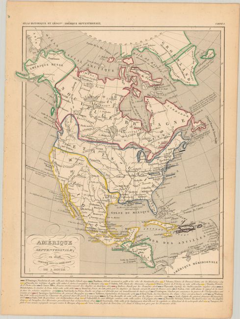
The United States and Great Britain established in 1818 joint claim over the Oregon Territory - the region north of Spanish controlled Upper California up to the southern boundary of Russia's Alaska Territory at North latitude 54°40'. By the late 1830's this arrangement was beginning to fall apart.
In the 1840's the expansionist Democrats, including their 1844 presidential candidate, James Polk, claimed the entire region for the United States. Their expansionist desires were expressed by Polk's famous campaign slogan, "Fifty-four Forty or Fight!" The slogan also became a rally cry for Americans desiring to settle the territory. Following Polk's election, the dispute was resolved by the 1846 Treaty of Oregon, which struck a compromise that fixed the U.S./Canadian boundary at 49º North.
This great French atlas map provides a view of North America in 1846. The border between the United States and Canada reflects the U.S. interests into present-day British Columbia, extending to about 55° North latitude. The borders of the Republic of Texas are still delineated, but the colorist on this example depicts it as a Mexican possession, even though it was annexed to the United States by 1846. Alaska is Amerique Russe. Mexico controls the bulk of the West. Below the map is a short history of 28 regions and cities that are keyed to the map via color-coding and numbering.
References: Phillips (Atlases) #110-98.
Condition: A
Contemporary color on a faintly toned sheet with a tiny edge tear in the right blank margin.