Subject: North America
Period: 1791 (circa)
Publication: A New Authentic System of Universal Geography...
Color: Black & White
Size:
16.8 x 10.4 inches
42.7 x 26.4 cm
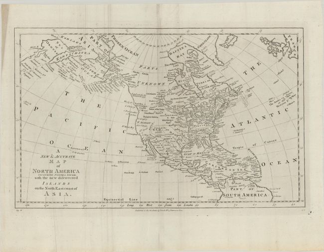
This is the second state of this map of North America focusing on discoveries in the Pacific Northwest and Alaska. Alaska is still a bit misshapen, but Captain Cook's discoveries are shown, and there is good detail of the Aleutian Islands. The northeast coast of Asia is depicted with a well formed Kamtschatka Peninsula. Northern Canada is marked Parts Unknown, and northern California is New Albion. New Mexico encompasses present-day Louisiana and Texas, while the eastern seaboard states all extend to the Mississippi River. On the continent, the political divisions are delineated by dotted lines, and numerous Indian nations are located. The map was published by Charles Cooke in a later edition of Thomas Bankes's A New Authentic System of Universal Geography...; across the top neatline is a mostly erased imprint reading, "Engraved for Bankes's New System of Geography." Although there is no engraver's signature, Thomas Bowen is known to have prepared the maps for Bankes's New System of Geography.
References: McCorkle (18th C. Geography Books) #11-8; Shirley (BL Atlases) T.BANK-1b.
Condition: B+
Issued folding, now flat, on paper with a fleur-de-lis watermark and some extraneous creasing.