Subject: Western Hemisphere - America
Period: 1825 (dated)
Publication: Atlante Storico, Geografico...
Color: Hand Color
Size:
19.1 x 12.9 inches
48.5 x 32.8 cm
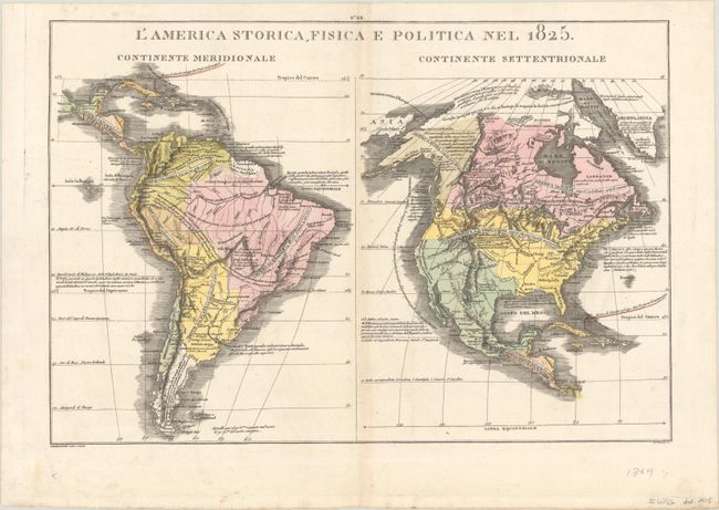
This handsome, uncommon map appeared in an Italian edition of Le Sage's historical atlas published by Girolamo Tasso. The sheet features two maps: South America at left and North America at right. Both continents are surrounded by Italian-language annotations providing information about the various regions. Area and population figures are shown as well. In the North America map, the population of the United States is shown as ten million. Lewis and Clark's expedition is delineated, and the map reflects the major expeditions of Pike, Long, and Humboldt. There are only sparse, vague boundaries, and a scattering of cities are identified. The present-day southwestern United States is still part of Mexico; the region is described in a note as a pleasant but sparsely populated landscape. Texas is named and noted as the location of an asylum camp. Nuova California is identified for its vineyards, olive trees, and wheat. Alaska is America Russa, with an estimated population of nomadic indigenous peoples numbering half a million. South America is full of interesting annotations. The mythical Lago Xarayes is located, although it apparently only forms during the rainy season. Engraved by Giovanni Valerio Pasquali.
References: Phillips (Atlases) #127-20.
Condition: A
A crisp impression in contemporary color with a hint of toning along the centerfold.