Subject: Algiers, Algeria
Period: 1628 (published)
Publication: Cosmographia, das Ist Beschreibung der Gantzen Welt
Color: Hand Color
Size:
7.1 x 5.8 inches
18 x 14.7 cm
Sebastian Munster (1489 - 1552) was one of the three most renowned cartographers of the sixteenth century, along with Mercator and Ortelius. Munster's Geographia and Cosmographia Universalis were two of the most widely read and influential books of the period. His editions of Ptolemy's Geographia, published between 1540 and 1552, were illustrated with 48 woodcut maps, the standard 27 Ptolemaic maps supplemented by 21 new maps. These new maps included a separate map of each of the known continents and marked the development of regional cartography in Central Europe. The antique geography was a prelude to Munster's major work, the Cosmographia, which was published in nearly 30 editions in six languages between 1544 and 1578 and then was revised and reissued by Sebastian Petri from 1588 to 1628. The Cosmographia was a geographical as well as historical and ethnographic description of the world. It contained the maps from the Geographia plus additional regional maps and city views with nearly 500 illustrations which made it one of the most popular pictorial encyclopedias of the sixteen century.
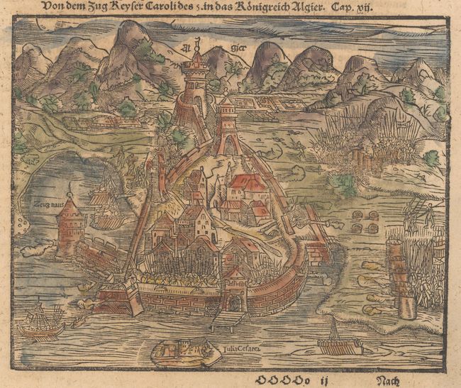
Woodblock illustration of the mighty fortress of Algiers, a major hub for Barbary coast pirates. In 1541 Emperor Charles V sent an expedition against Algiers to deprive the pirates of their base. The fleet was diminished by a storm and then defeated by the Algerians, and Algiers continued to be among the most prominent bases of the Barbary coast pirates. On a sheet of German text measuring 9.3 x 14.3".
References: Shirley (BL Atlases) T.MUN-1o #258.
Condition: B+
Light soiling with a dampstain in the top portion of the sheet.