Subject: Central England
Period: 1695 (circa)
Publication: Britannia
Color: Black & White
Size:
14.2 x 11.3 inches
36.1 x 28.7 cm
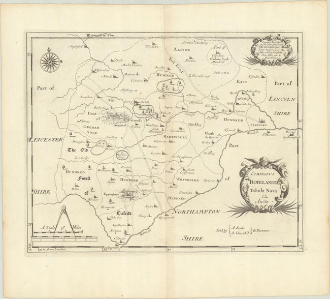
This is a close copy of Saxton and Speed's work and an early county map with roads delineated. The large towns of Okeham and Uppingham feature a street grid pattern in false 3-D. It locates forests, villages, rivers and the various districts including East Hundred, Martinsley, The Old Forest of Liefeild, etc. The bordering towns of St. Martins and the Burley by Stamford in Northamptonshire and Rockingham in Leicestershire are located. Distance scale with dividers, nice compass rose, and two fancy cartouches complete a pleasing composition. Sold by A. Swale and A. Churchil.
Morden was one of the first English cartographers to show longitudes measured from the meridian of St. Paul's Cathedral (shown in degrees at the bottom of the map) and time in minutes measure locally from the sun (shown at the top in Roman numerals). The roads on his maps are based on Ogilby's earlier survey. The Britannia was first published by historian William Camden (1551-1623) in 1586. After the publication of the final edition of Britannia in 1637, the work was not published again until 1695 when Gibson revised and translated the text from the original Latin and included fifty maps, mostly of the English counties, prepared by Robert Morden, replacing the outdated maps of Christopher Saxton.
References: Shirley (BL Atlases) T.CAMD-5a.
Condition: A
A crisp impression with minor toning along the centerfold.