Subject: Central Virginia, Civil War
Period: 1867 (dated)
Publication: Military Maps Illustrating the Operations of the Armies of the Potomac and James
Color: Hand Color
A. Richmond... (33.2 x 21.8"). This detailed, large-format map of the vicinity of Richmond extends eastward about 16 miles to include all battle lines in color. Shows common roads, railroads, and fortifications (Union in blue; Confederate in red). Richmond and Manchester are shown with street detail with a ring of heavy fortifications surrounding both. A concentration of troops is shown north of the Chickahominy River near New Cold Harbor and Old Cold Harbor. Reference: Stephenson (CW) #632.8. Condition: Lightly toned with a couple of tiny spots at bottom. There are old tape repairs to small centerfold separations at top, center and bottom and to a couple of short edge tears at left and right. (B)
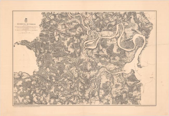
B. Bermuda Hundred... (28.8 x 19.2"). A detailed map of the Civil War battlefield in the vicinity of Bermuda Hundred. Features an attractive burnt umber background with the Union and Confederate entrenchments colored in strong blue and red. Map shows common roads, railroads, towns, vegetation, relief by hachure, houses and names of residents. Locates City Point, Chester Station, Fort Brady, Fort Clifton, Fort Converse, etc. Reference: Stephenson (CW) #525B.2. Condition: The map image is mostly clean and crisp with an 8" edge tear at right that has been closed on verso with archival tape. (B+)
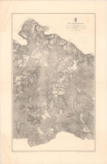
C. The Wilderness... (18.3 x 30.3"). This rural area of central Virginia is about 20 miles to the west of Fredericksburg. The map is bounded by the Rapidan River to the north and the Orange Courthouse Plank Road to the south. Union and Confederate entrenchments to the west of the Wilderness Tavern at center are shown in strong blue and red. Reference: Phillips (A) Vol 3, #3688-4. Reference: Stephenson (CW) #665.9. Condition: There are dampstains in the top and bottom left corners of the sheet that just touch the map border. (B+)
All maps surveyed under the direction of Nathanial Michler and Peter Michie. Lithographed by Julius Bien.
References: Phillips (Atlases) #3688.
Condition:
See description above.