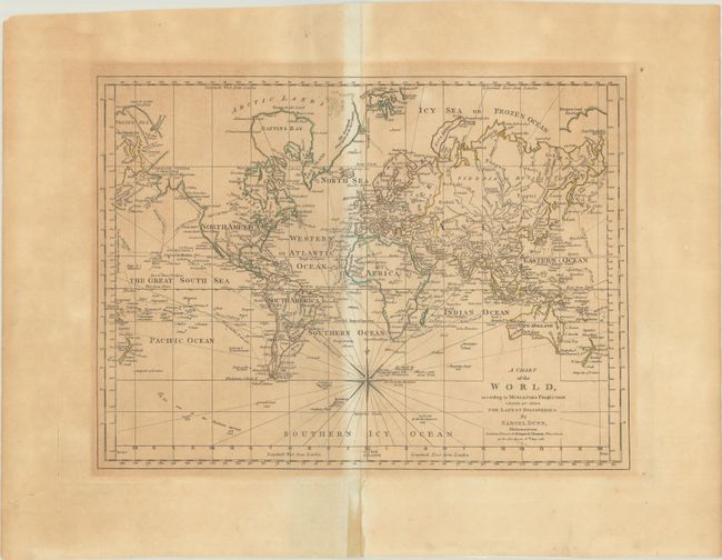
Subject: World
Period: 1781 (dated)
Publication:
Color: Hand Color
Size:
16.3 x 12.1 inches
41.4 x 30.7 cm
This atlas map traces the routes of several explorers, including Chirikov, Byron, Bougainville, and, on this edition, the latest expeditions of Captain Cook. Present-day Alaska is labeled Stachtan Nitada or Great Land Discovered by the Russians 1730, and its northern extent is left undefined. North of Cape Tchouktchis is a Frozen Sea and an incomplete stretch of coast identified as Great Land Inhabited. The eastern coast of the present-day United States and Canada is shown as British Colonies, with Louisiana Territory west of the Mississippi. A conjectural River of the West appears north of New Albion. In Australia, Diemens Land is still attached to the main island. Peppered throughout the southernmost regions of the map are several notations of ice sightings in the ocean. The map was first published in Dunn's A New Atlas of the Mundane System... (1774); this is a later edition with the date in the imprint updated to 1781. Printed in London for R. Sayer & J. Bennett.
References: cf. Shirley (BL Atlases) T.DUNN-1a #2.
Condition: B
A crisp impression with contemporary outline color on a sheet with a Strasbourg bend and lily watermark. There is uneven toning and color offsetting around the centerfold. A centerfold separation in the bottom blank margin has been repaired on recto with cello tape and on verso with archival tape.