Catalog Archive
Auction 189, Lot 111

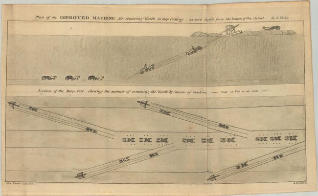
"[Map with Report] Map of the Niagara Peninsula Shewing the Course and a Profile of the Welland Canal. Connecting Lakes Erie and Ontario by Ship Navigation [with] The American Journal of Science and Arts",

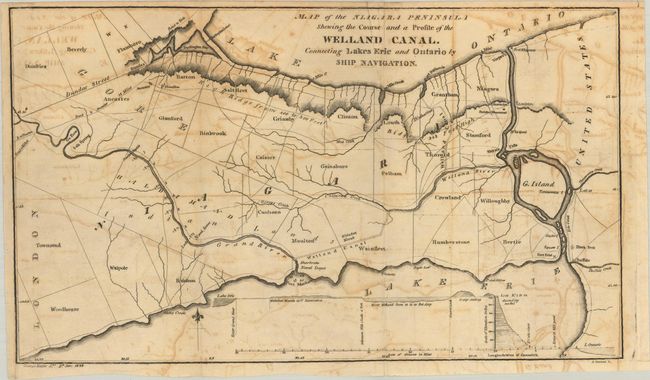
Subject: Welland Canal, Lake Ontario & Lake Erie

Period: 1828 (published)

Publication:

Color: Black & White

Size:
14.5 x 8.5 inches
36.8 x 21.6 cm
Download High Resolution Image
(or just click on image to launch the Zoom viewer)

This map by George Keefer Jr. shows the Welland Canal, completed in 1829, connecting the Welland River to the Grand River. The opening of this canal allowed ships to bypass Niagara Falls and opened Great Lakes ports to international shipping through Montreal and Quebec City. A small profile at bottom reveals that the lock system had to overcome 300 feet of elevation between the two lakes. Engraved by Amos Doolittle. The map is accompanied by William Hamilton Merritt's “Account of the Welland Canal” within a complete disbound issue of The American Journal of Science. This issue also includes a plate showing the method used to dig the canal as well as a small map of the Louisville and Portland Canal. There are no past sales records and only two institutional holdings per OCLC.

References:

Condition: B

The folding map has some offsetting. Disbound text has light toning and scattered foxing.

Estimate: $180 - $220

Sold for: $240

Closed on 9/14/2022

Archived