Subject: Western Africa
Period: 1681 (circa)
Publication:
Color: Hand Color
Size:
34.3 x 19.6 inches
87.1 x 49.8 cm
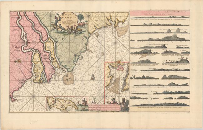
This elegantly engraved and very decorative sea chart covers the coast of Western Africa from the mouth of the Gambia River south to the Sierra Leone River. The chart is crisscrossed by rhumb lines and is full of navigational information. A compass rose capped with a fleur-de-lis orients north to the left. Inland information is sparse except for place names along the banks of the various rivers depicted. This edition includes an inset at bottom showing the island of Goree, one of the first areas of Africa to be settled by Europeans, now associated with the Atlantic slave trade. Another inset at right details the Tagrin Bay and the mouth of the Sierra Leone, complete with depth soundings and anchorages. Neptune, Triton, a hippocampus, and other allegorical figures appear around the distance scales at bottom. The striking title cartouche features a native figure raising an ax and a monkey fleeing a pair of snakes. This example includes a half sheet, joined to the chart, depicting land approach views.
References:
Condition: A
A sharp impression in full contemporary color with a small rust spot in the Tagrin Bay inset, a bit of wear along the folds, and light soiling that is mostly confined to the blank margins.