Subject: Northern Africa
Period: 1574-98 (published)
Publication: La Geografia di Claudio Tolomeo Alessandrino…
Color: Black & White
Claudius Ptolemy was a mathematician, astronomer and geographer who worked in Alexandria, then a part of the Roman Empire, in the 2nd century AD. One of the most learned and influential men of his time, his theories dominated both astronomy and geography for nearly 1500 years. His writings were kept alive by Arabic scholars during the Middle Ages and reemerged in Europe during the Renaissance. The birth of printing led to wide dissemination of his great works on astronomy and geography. There were a number of editions of his Geographia beginning in 1477. These early editions contained maps based on his original writings, known as Ptolemaic maps. As geographic knowledge increased with the explorations of Columbus, Magellan, Cabot and others, maps of the New World were added, and maps of the Old World were revised. Ptolemy's Geographia continued to be revised and published by some of the most important cartographers including Martin Waldseemuller, Sebastian Munster, Giacomo Gastaldi, Jodocus Hondius, and Gerard Mercator (whose last edition was published in 1730).
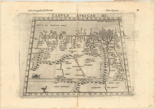
A. Tabula Africae III, published 1598 (9.8 x 6.9"). Finely engraved Ptolemaic map of eastern Libya and Egypt with numerous ancient place names. Depicts the course of the Nile River beyond Aswan in southern Egypt. The interior is filled with mountains as well as some spurious lakes and rivers. Drawn on a trapezoidal projection with a stippled sea. This is a later edition with the addition of an ostrich and a pair of lions. Italian text on verso. Condition: A dark impression on a bright sheet with toning along the centerfold. There are centerfold separations and worm tracks along the centerfold that have been archivally repaired, as well as small worm holes in the blank margins. (B)
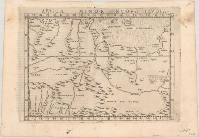
B. Africa Minor Nuova Tavola, published 1574 (9.5 x 6.8"). This Ptolemaic map of northern Africa depicts portions of Algeria, Tunisia, and Libya and extends to include part of the Mediterranean Sea including Malta. The map locates rivers, lakes, mythical mountain ranges, and a forest named Silviofera Silva. Decorated a stippled sea with Italian text on verso. Condition: On watermarked paper with two light dampstains confined to the side margins. (A)
References: Mickwitz & Miekkavaara #227-13 & #220-48.
Condition:
See description above.