Subject: Asia
Period: 1619 (published)
Publication: Gerardi Mercatoris - Atlas sive Cosmographicae
Color: Hand Color
Size:
19.8 x 14.8 inches
50.3 x 37.6 cm
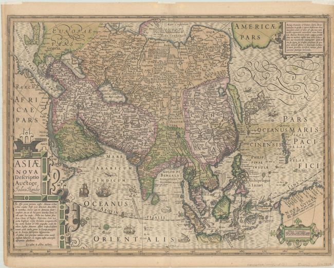
This excellent map of Asia was Hondius’ update of Mercator’s map of 1595. Though it corrected many of Mercator’s errors, the map still has many interesting early depictions. Korea is shown as a very long island. Japan is depicted on the Ortelius-Teixeria model with three principal islands. In India, the Gulf of Cambay is very exaggerated but the shape of Ceylon has been improved. The mythical Chami Lacus appears to the northeast of India. The Philippines are marked as the Philippina Insulae, as well as Archipelagus S. Lazari, Magellan’s original name for the group. The southern coastline of Java is left blank. The northern coastline of New Guinea includes many place names from Spanish expeditions, and there is a note that it is unknown if New Guinea is a part of Terra Australis. Across the Anian Fretum lies part of North America, labeled Americae Pars, with a cartouche notation concerning the searches for a Northwest Passage. The map is richly decorated with strapwork cartouches, ships, and numerous sea monsters. French title and decorative engraving on verso.
References: Yeo #20; Walter #24; Van der Krogt (Vol. I) #8000:1B.
Condition: B
Full contemporary color with light soiling, show-through of the color on verso (the triangular area at right), and professionally remargined at left. There are some tiny chips along the right edge of the sheet, a tiny centerfold separation at bottom, and remnants of hinge tape along the top edge of the sheet on recto. Narrow side margins.