Subject: Spitsbergen, Norway
Period: 1659 (published)
Publication: Novus Atlas, Vol. V
Color: Hand Color
Size:
20.3 x 16.3 inches
51.6 x 41.4 cm
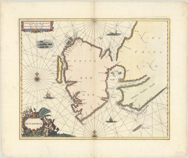
This rare and boldly engraved chart of Spitsbergen was published in Volume V of Jansson's Novus Atlas, his pioneering sea atlas. Spitsbergen was first noted by Willem Barentsz in 1596 and became an important station for English and Dutch whalers in the 17th century. Jansson's chart is one of the first charts to focus exclusively on the region, after Blaeu's map of 1623. A narrow, ambiguous inlet separates Spitsbergen from Nieu Friesland. Several smaller islands are identified, including Voorland (Forlandet) and Hoopen Eyland. Unsurprisingly given Jansson's nationality, the place names along the coasts are Dutch; as Pool points out in his article for IMCOS, English cartographers had their own competing set of English-language toponyms reflecting their claim to the region. There is no information on the inland areas. The chart is decorated with a whaling vignette, a sea monster, sailing ships, and two compass roses radiating rhumb lines. There is an ornate title cartouche at bottom left featuring Neptune, sea monsters, harpoons, and putti. Another cartouche enclosing two distance scales appears at top left. This chart only appeared in three editions of Jansson's atlas and is therefore rare on the market today; most examples on the market are the edition with Valck and Schenk's imprint. Latin text on verso.
References: Pool (IMCOS #121) pp. 38-42; Van der Krogt (Vol. I) #1260:1.
Condition: A
A fine impression with archival repairs to centerfold separations in the top and bottom blank margins.