Subject: World
Period: 1798 (circa)
Publication: Atlas de Voyage de la Perouse
Color: Hand Color
Size:
36.6 x 23.1 inches
93 x 58.7 cm
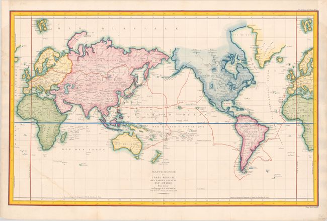
Jean-Francois de Galoup, Comte de La Perouse commanded a French scientific expedition to the Pacific in 1785-88. Recognized as one the foremost naval commanders and navigators in France, he was selected by King Louis XVI to complete Captain James Cook's exploration of the western Pacific. The British Admiralty provided scientific equipment to measure variations in magnetic compass readings and with the latest instruments for determining longitude. La Perouse explored the coasts of the Gulf of Alaska and northwestern North America in search of the fabled Northwest Passage. After leaving America his expedition continued on to Asia where he explored from Macao to Kamchatka and the Solomon Islands in the South Pacific. La Perouse was meticulous in sending copies of his extensive logs, maps and surveying information via other ships as well as overland. La Perouse's last contact was in the spring of 1788 with a British ship in Botany Bay, Australia. The expedition was never heard from again. Considered one of the greatest French voyages, the French Government decided to publish the story of the expedition when it became clear they had been lost. An English edition was published in London.
This is the first edition of this large, important map of the world illustrating the voyage of La Perouse. The track of the doomed expedition of 1785-88 is displayed from France to Cape Horn, across to Hawaii, up to the Pacific Northwest, west to the eastern coast of Asia up to Kamchatka and south to Botany Bay, where their path disappears. The remains of their vessels were found in 1826, north of New Hebrides. The map shows up-to-date information gleaned not only from La Perouse, but also from the expeditions of Cook and Mackenzie. The price is indicated at bottom right: "Prix Trois Francs."
References: Hayes, pp. 65.
Condition: B
A crisp impression on a bright sheet with a "Depot de la Marine" watermark, some errant splatters of color, and a few short tears along the edges of the sheet, most of which have been archivally repaired. There is a chip at top left and a tear through the bottom corner of the map that have both been archivally repaired.