Subject: Virginia, Civil War
Period: 1862 (dated)
Publication:
Color: Black & White
Size:
37.4 x 25.6 inches
95 x 65 cm
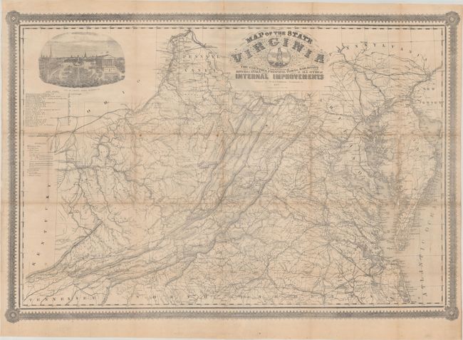
This is the first edition of this rare map of Virginia made in Richmond for Confederate officers of the American Civil War. The map is derived from an 1858 map of Virginia by Ludwig von Bucholtz, who was commissioned to revise the 1826 Hermann Boyne 9-sheet map of Virginia. The product of his exhaustive work was issued by Ritchie & Dunnivant in 1858 and was widely regarded as the most accurate map of Virginia for its time.
John M. West and Thomas Johnston, both transplanted Yankees with no previous map publishing experience, acquired the Bucholtz lithographic stone. West & Johnston added a new decorative border and an updated table of railroads to the map and began printing and selling it in 1862 to both civilian and military customers. This map represents one of the few Confederate imprints that appeared at the time, largely due to a lack of resources in the south. While numerous maps poured out of Northern publishing houses during the Civil War, Confederate imprint maps were "characterized by [...] improvisation and frugality" (Wooldridge, p. 287). In fact, West & Johnston published an 1864 edition of this map, ostensibly changing only the date on the cover without adding any new geographical information.
The map shows all of Virginia, West Virginia, Maryland, Delaware, and parts of New Jersey and Pennsylvania. A detailed bird’s-eye view of Capitol Square in Richmond adorns the top left corner of the map and a chart below the view lists all the railroads with the length of each line. A reference key notes important information for military officers, which includes principal cities, state and county lines, railroads (completed, in progress, and proposed), canals, rivers, plank roads, court houses, telegraph lines, and stations to name a few.
West & Johnston ceased publishing this map well before the Civil War ended, and after the burning of Richmond in 1865, it is likely that many examples of this map were destroyed. At the time, the map cost $2.50, a considerable amount of money for most people in the mid-19th century. As a result, this map is very rare, with most surviving examples in poor condition and without the original covers.
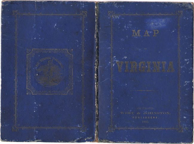
This example is accompanied by its original blue stiff paper boards with gilt title on the front cover.
References: Stephenson (Civil War) #475.5; Wooldridge #254.
Condition: B+
Issued folding and now flattened and professionally backed with tissue to reinforce and repair numerous fold separations. There is some minor loss at several fold junctions and a few spots of foxing in the image. Accompanying covers are worn and soiled.