Subject: World
Period: 1755 (dated)
Publication:
Color: Hand Color
Size:
32.3 x 21.3 inches
82 x 54.1 cm
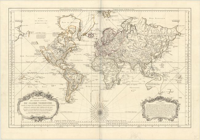
This is the rare first edition of Bellin's very large world chart on Mercator's projection, prior to the addition of the stamp of the Depot de la Marine. North America is shown with a partial Mer de l'Ouest, and the Russian discoveries of 1728 and 1741 in the Northwest. There are notations concerning the supposed discoveries of Admiral Fuentes and the continued search for the passage by the British, but the possibility of a Northwest Passage is discounted by Bellin, who writes that the theory is "suspect" and "there is reason to believe that there is none." There is an odd river and lake network connecting Hudson Bay with Lake Superior. Australia is shown as Nouvelle Hollande with Terre de Diemen, New Guinea and Terre du S. Esprit (New Herbrides) linked to the mainland. A partial coastline of New Zealand and the Soloman Islands appear in the Pacific. Large, decorative title and distance scale cartouches and a fine compass rose with rhumb lines.
References: McGuirk #45.
Condition: B+
Contemporary outline color on a sturdy sheet with a watermark, light stains in the Pacific and along the centerfold at bottom, an extraneous crease at bottom center, and an archivally repaired centerfold separation at bottom.