Subject: California & Nevada
Period: 1908 (published)
Publication: Atlas of Maps and Seismograms ... Earthquake Investigation Commission...
Color: Printed Color
These three maps were issued in the Atlas of Maps and Seismograms Accompanying the Report of the State Earthquake Investigation Commission upon the California Earthquake of April 18, 1906. The report, commonly known as (Professor Andrew) Lawson's report, sought to provide detailed scientific knowledge from the devastating effects of The Great 1906 San Francisco Earthquake, which still today ranks as on of the most significant earthquakes of all time. The USGS notes that "the 1906 earthquake and the Lawson report demonstrated the importance of accurate, widespread and repeated observations of earthquakes, their effects, and the faults on which they occur. The report provided the basis for much of what is now known about earthquakes in California. The detailed surveys described in the Lawson report show that the damage to buildings in the earthquake was strongly related to both the design and construction of the structure and the local geology -- the type of soil or rock on which it was built." The two volume report was accompanied by an atlas volume, which included the following maps by A. Hoen:
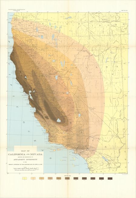
A. Map of California and Nevada Showing the Distribution of Apparent Intensity in the Region Affected by the Earthquake of April 18, 1906 (20.0 x 26.3"). Presents the apparent intensity of the earthquake via a color-coded scale, with the greatest effects shown along the coastal areas and valley to the north of Tulare Lake. Drawn by M. Solem.
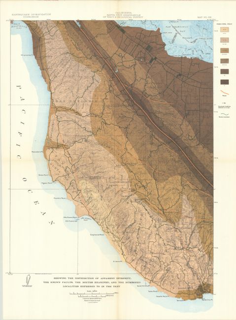
B. California Santa Cruz Quadrangle of the U.S. Geological Survey (14.7 x 20.5"). Extends from the San Francisco Bay west to Half Moon Bay and south to Santa Cruz, and uses a six-color scale to indicate intensity. The map also indicates the known faults and numerous routes examined.
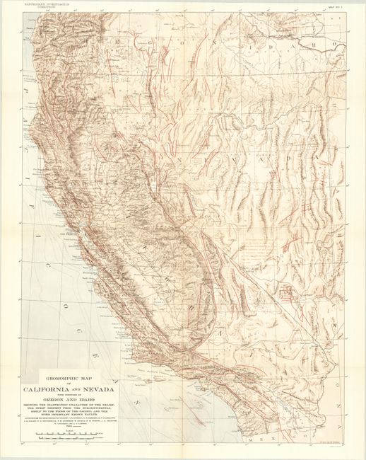
C. Geomorphic Map of California and Nevada with Portions of Oregon and Idaho..., (20.0 x 26.3"). Identifies the numerous known faults in the region through red overprinting. Extends to include data in southern Oregon and Nevada.
References:
Condition: A+
Clean, colorful, and fine. Issued folding.