Subject: Western Hemisphere - America
Period: 1820 (circa)
Publication:
Color: Hand Color
Size:
29 x 20.4 inches
73.7 x 51.8 cm
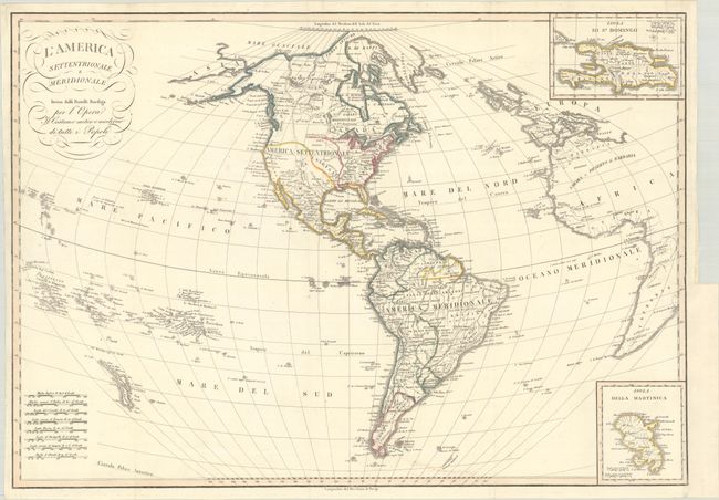
This scarce Italian map features fine engraved lines and an unusual projection. In North America, Alaska is fairly well formed and labeled Alaska in the western end of the Alaska Peninsula. The United States extends to the Mississippi, with Luigiana (Louisiana Territory) to its west. Texas is named along the R. aux Cannes, and New Mexico is a narrow column bounded by the Rio Grande that includes Santa Fe and Taos. South America is well shown with all political divisions delineated and the mythical lakes of Parime and Zarayes located. The map extends to part of Africa and Europe, and all of Great Britain. In the Pacific Ocean, the map identifies the Sandwich Islands, New Zealand, and various Pacific island chains. There are two insets: Isola de St. Domingo (top right) and Isola Della Martinica (bottom right). The title contains flourishes and some script. Eight distance scales are stacked at lower left.
References:
Condition: B+
Issued folding, now flat, with a binding trim in the right margin that has been replaced with old paper and two associated tears that have been archivally repaired on verso. There is minor soiling along the bottom of the map image and a tiny hole in an unengraved area in the Pacific that has been infilled with archival materials.