Subject: Western Hemisphere - America
Period: 1755 (circa)
Publication:
Color: Hand Color
Size:
23.4 x 18.7 inches
59.4 x 47.5 cm
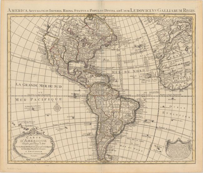
Originally published in 1722, Guillaume Delisle's map of the Americas was one of the most popular maps of the 18th century, with numerous editions published. Its various editions provide a great view of the evolving cartographic knowledge of the Americas throughout the eighteenth century. This is the rare sixth state published in Amsterdam by Covens & Mortier with the addition of a Latin title at top: America Accurate in Imperia, Regna, Status & Populos Divisa. In North America the western coast is now continued northward above Cap Blanc to include an early appearance of a large Sea of the West (Mer de l'Ouest). The region of central Canada has been extensively updated to included several large lakes and forts. The French territory of Louisiane takes up the lion's share of North America at the expense of the British colonies. This political bias is due to Delisle's position as geographer to the King of France. The west end of Hudson Bay is completed, and the names reflect recent British explorations in the region. Halifax and Philadelphia are now named. South America is much better represented, with a good depiction of the river systems and locations of the Jesuit missions. Several notations throughout the map have been extended in the edition.
References: McGuirk #47; Tooley (Amer) p. 14, #6, plt. 3.
Condition: B+
A crisp impression with contemporary outline color on a sturdy sheet with a "C & I Honig" watermark. There are short centerfold separations at top and bottom and an edge tear at bottom that have all been closed on verso with archival materials.