Subject: Western Hemisphere - America
Period: 1746 (dated)
Publication:
Color: Hand Color
Size:
25.1 x 19.3 inches
63.8 x 49 cm
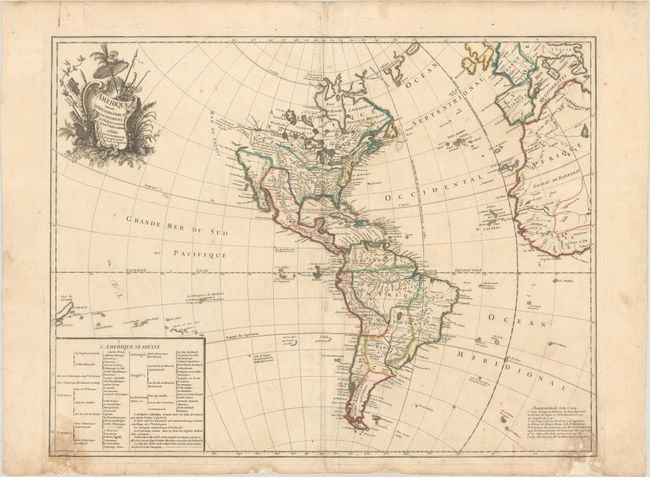
This fascinating map shows the recent discoveries in North and South America. The entire northwest coast of North America is completely blank with the bold Riv. de l' Ouest (River of the West) stretching from Lake Superior to the Pacific, based on the reports of the Jesuit missionary, Pierre de Charlevoix. In South America the Amazon River is detailed according to Charles Marie de la Condamine's expedition. This is a very early record of Condamine's incredible 10-year adventure from 1735-45; his journal of the expedition was not published until 1751. A text table details the colonial possessions. McGuirk identifies this as the first state, but we have since found an earlier example that does not include the note at bottom right regarding changes to the map's cartography.
References: Map Collector #64, p. 18-23; McGuirk #15.
Condition: B
On a sheet with a rosary beads watermark and some small, archivally repaired chips in the lower margin, a few of which enter into the map image, with a tiny portion of the neatline replaced in facsimile. There are a couple dampstains at bottom, light soiling, and a 3.5" centerfold separation at bottom that has been repaired with archival materials on verso.