Subject: Western Africa
Period: 1732 (circa)
Publication: A Collection of Voyages and Travels...
Color: Hand Color
Size:
14.4 x 9.9 inches
36.6 x 25.1 cm
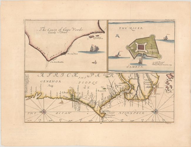
This sheet features three elegantly engraved maps of the Guinea Coast. It first appeared in Volume V of Awnsham and John Churchill's A Collection of Voyages and Travels... in 1732. The map draws on the accounts of John Barbot, a French Huguenot slave trader, who made two journeys to Western Africa in 1678 and 1682. The main chart covers the coast of West Africa from Penia, "where the Dutch do Now trade For ye Gum Arabick Since the taking of Arguyn," south to the Bissagos Islands, centering on the Cap-Vert peninsula. Place names, rivers, roads, and tribal names appear along the coast, with soundings and anchorages in the water. Two compass roses orient the north to the left. At top left is a smaller map that zooms in for a closer look at Cap-Vert. To its right is a small view of James Island (now called Kunta Kinteh Island) with a plan of Fort James. A note below the island reads, "72 Guns Mounted 30 Dismounted When ye French Took it in 1695." Engraved by Johannes Kip.
References: Shirley (BL Atlases) G.CHUR-1a #47.
Condition: A
Issued folding, now flat, with a few tiny spots.