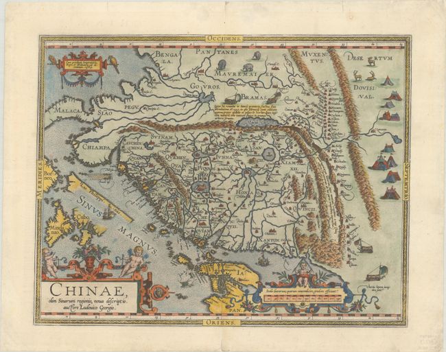
Subject: China
Period: 1584 (dated)
Publication: Theatrum Orbis Terrarum
Color: Hand Color
Size:
18.5 x 14.5 inches
47 x 36.8 cm
This landmark map provides a fascinating view of the mysterious orient from a Renaissance perspective. Ortelius based the map on the work of Jorge de Barbuda, a Portuguese Jesuit also known as Ludovicus Georgius, whose manuscript map reached Ortelius by way of Arias Montanus. The depiction, which became the standard image of China for over half a century, shows the legendary kingdom at an early point in European exploration of the region. The map is oriented with north to the right and extends into parts of Indo-China, the Philippines and part of Japan. The Great Wall is prominently delineated and several huge lakes and rivers dominate the topography. Two mythical lakes are included: Chiama Lacus (Lake Chiamay) with five rivers flowing south; and a larger lake simply labeled Lacus that is purported to be the source of the Yellow River. Illustrations in the interior include tent cities of the Tartars, stags, elephants and elaborate sail-powered carriages. The map is further adorned with three ornamental cartouches. This is the third state with las Philippinas added above Sinus Magnus and additional crosshatching on the wind wagons, published in the French edition of 1598.
References: Caboara #1.3; Walter #11F; Van den Broecke #164.
Condition: A
A sharp impression on a bright sheet with professional repairs to short centerfold separations at top and bottom and to some tiny chips and tears along the edges of the sheet.