Catalog Archive
Auction 187, Lot 58

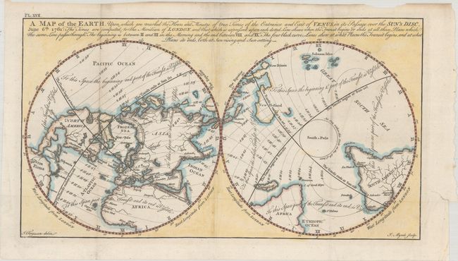
Scarce Polar Map Showing the Transit of Venus and the Sea of the West

"A Map of the Earth, Upon Which are Marked the Hours and Minutes of True Times of the Entrance and Exit of Venus in its Passage over the Sun's Disc, June 6th. 1761...", Ferguson, James

Subject: Cartographic Miscellany, World

Period: 1770 (circa)

Publication: Astronomy Explained Upon Sir Isaac Newton's Principles

Color: Hand Color

Size:
14.3 x 7.9 inches
36.3 x 20.1 cm
Download High Resolution Image
(or just click on image to launch the Zoom viewer)

This scarce double hemisphere map depicts the world from a polar perspective and illustrates the passing of the planet Venus between the Earth and sun in the year 1761. Dotted lines show the times that the transit begins and ends at various locations. Each hemisphere is divided into quadrants where the transit is marked as visible or not visible. In North America, there is a prominent Sea of the West, with a few large islands within it. The coast of New Holland (Australia) is incomplete and attached to a partially mapped Papua New Guinea. This is the second state, published as Plate XVII in the third volume of Astronomy Explained Upon Sir Isaac Newton's Principles. Engraved by J. Mynde.

References: McGuirk #100.

Condition: B+

A crisp impression issued folding, now pressed, with some minor extraneous creasing and light soiling, much of it confined to the blank margins. A binding tear confined to the right margin has been repaired with archival tape.

Estimate: $200 - $230

Sold for: $150

Closed on 4/27/2022

Archived