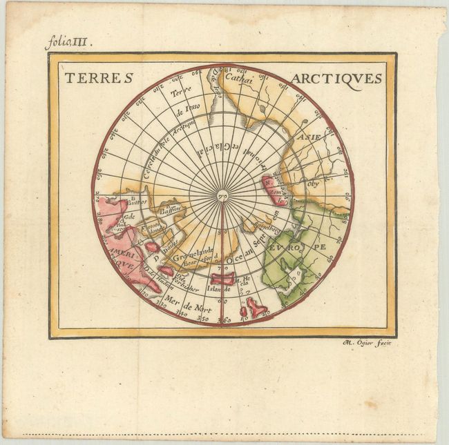
Subject: North Pole
Period: 1688 (published)
Publication: La Geographie Universelle
Color: Hand Color
Size:
4.8 x 3.9 inches
12.2 x 9.9 cm
Finely engraved miniature map of the North Pole detailing Hudson, Button and Baffin bays, based on John Seller's polar projection. Although Kershaw indicates this is the third state, Burden correctly identifies it as cut from a different plate as other states. Although this edition closely follows the original, first published in 1661, some changes have been made. Most notably, it bears the engraver's signature (R. M. Ogier) at bottom and much of the regional nomenclature has been omitted. Whereas previously there were two fictitious islands (Spigelberg and Villoubi) just above the real island of Novaya Zemlya, now only Spigelberg remains. The partial coastline of Terre de Iesso extends further, and the Strait of Iesso has been added. Northeast Russia is now named Cathai rather than Tartarie. Published by Jean Certe in Lyons for Duval.
Pierre Duval was Nicolas Sanson's nephew and pupil. He published a wide range of atlases and individual maps including a fine miniature world geography with many of the maps based on Sanson.
References: Burden #646; Kershaw #255; King (2nd ed) pp. 132-135; Pastoureau, Duval XI H [2].
Condition: A
A crisp impression on a bright sheet, issued folding with light dampstains along the top edge of the sheet.