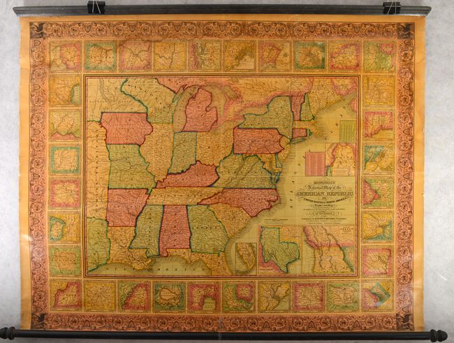
Subject: Eastern United States
Period: 1847 (dated)
Publication:
Color: Hand Color
Size:
47.6 x 37.6 inches
120.9 x 95.5 cm
This is a very nice wall map that was drawn by J.H. Young and engraved by J.H. Brightly. It extends into Texas, Indian Territory, Iowa, and Wisconsin with a large unorganized area to the west labeled Dacotah or Sioux. Large insets within the map include the new state of Texas (with its largest borders), the southern tip of Florida, a "Map of the North-Eastern Boundary of the United States according to the Treaty of 1842" which details the Webster-Ashburton Treaty, and another detailing Oregon Territory. The map is very detailed with hundreds of place names, roads, villages, railroads, ports, and more. A table gives the 1840 population for 120 cities and another gives the states' population of Whites, Free Blacks and Slaves. The state of New Hampshire is listed with only one slave. Surrounding the map are 32 city plans which itself is contained with a wide decorative border. The map is still attached to its original wooden rollers. This large wall map should not be confused with the smaller (24 x 34") and more common map with the same title.
References:
Condition: B
The map is mostly very clean and bright with some light dampstains along the top border and upper right border. There are 6" and 2" tears at top that have been backed with archival tape for stabilization. Original rollers are present and attached.