Subject: Eastern United States, Republic of Texas
Period: 1844 (circa)
Publication:
Color: Hand Color
Size:
22.9 x 17.7 inches
58.2 x 45 cm
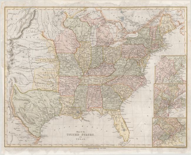
This detailed map extends as far west as the Republic of Texas, the Rio Grande, and Santa Fe. It is a fine illustration of the expansion that was taking place at this time in history with settlement filling in the Mississippi Valley and the Indian Districts dominating the plains region. The Republic of Texas is shown with plenty of towns and cities identified, including Austin, Houston, S. Antonio de Bexar, and Nacogdoches. North of Texas is a vast Indian Territory, and north of that is the Mandan District. Several tribes are located throughout the map. A note in the Great American Desert reads, "This Desert is traversed by immense herds of Buffaloes, and inhabited by roving tribes of Indians." Along the western edge of the map, the Black Hills, Long's Peak, Pikes Peak, and Spanish Peaks are located. Fort Laramie, Gants Fort, and Bents Fort represent the tiny western military outposts of the United States. While the transportation network of roads and railways is well developed in the eastern states, the road from Independence Missouri to Santa Fe is the sole road shown west of the Mississippi River. Three insets at right zoom in on Boston, New York City, and Philadelphia and their respective outskirts. Engraved by C. Copley and printed on thin paper.
References:
Condition: A
Issued folding with a binding trim in the left margin that has been repaired with archival materials.