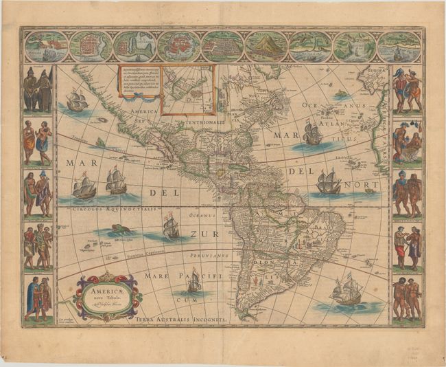
Subject: Western Hemisphere - America
Period: 1662 (published)
Publication: Atlas Maior
Color: Hand Color
Size:
21.7 x 16.3 inches
55.1 x 41.4 cm
This stunning carte-a-figures map is a superb example of the fine art of decorative cartography and a seventeenth-century European view of the New World. The coastal outlines generally follow Ortelius and Wytfliet with nomenclature from a variety of explorers and colonists. Panels at sides, each with five portraits of the native inhabitants, were taken from John White (Virginia), Hans Staden (Brazil) and other early explorer's accounts. Across the top are nine town plans including Havana, St. Domingo, Cartegena, Mexico City, Cusco, Potosi, I. la Mocha in Chile, Rio de Janeiro and Olinda in Brazil. This is one of the few maps of the Americas by this famous Dutch cartographer. The map itself is similar to Blaeu's wall map of 1608 with the additional discoveries of Henry Hudson in North America, and Tierra del Fuego with Le Maire Strait. This is the fourth state of the plate with the imprint changed to Auct: Guiljelmo Blaeuw and some re-engraving of the sea surrounding the ships and sea monsters. Latin text on verso.
References: Burden #189; Goss (Blaeu) p. 156; Tooley (Amer) p. 297; Van der Krogt (Vol. II) #9000:2.
Condition: B+
Nice example of this beautiful map with old color on a lightly toned sheet with an elephant watermark and a few small spots of foxing. Some separations and tears along the centerfold have been expertly repaired with a sliver of the image in North America skillfully replaced in facsimile.