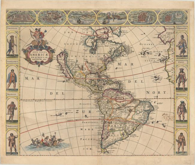
Subject: Western Hemisphere - America
Period: 1660 (dated)
Publication:
Color: Hand Color
Size:
21.6 x 17.3 inches
54.9 x 43.9 cm
An uncommon and splendid carte-a-figures map of the Americas. The map combines many different sources including the Luke Foxe model of the island of California. The only hint of the Great Lakes is a small L. Contenant at the end of the St. Lawrence River. Nieu Neder Land occupies the eastern seaboard, and there is no mention of any English settlement other than the name Virginia. In South America a large river and lake system provides the boundary of Brazil, with the mythical lake Eupana Lacus. A second mythical lake, Parime Lacus, is shown along the equator. The decorations were taken from van den Keere's map of 1614. The figures at sides depict the natives of Virginia, Magellanica, and Brazil, and the cities across the top include Cusco, Mexico, Olinda, Havana, S. Dominique, and Cartegena. The map is further embellished with a title cartouche bearing a native Indian mounted on an armadillo, and Neptune frolicking in the Pacific with mermaids and sea horses. This is the first state of this separately issued map, with the date in the title.
References: Burden #356; McLaughlin #24; Tooley (Amer) p. 116 #18.
Condition: B
A sharp impression with light soiling, a few old manuscript notations in the image, and professional repairs to a few minor separations along the centerfold. The map has been expertly remargined on all sides, and a chip at top right that extends into about half of the Cartagena vignette and into a quarter of the male Virginian figure has been repaired with the image skillfully replaced in facsimile.