Subject: Southern Australia & Tasmania
Period: 1851 (circa)
Publication: Illustrated Atlas and Modern History of the World
Color: Hand Color
Size:
9.8 x 13.6 inches
24.9 x 34.5 cm
The maps from The Illustrated Atlas were first published in serial form to a target audience that led insular lives due to the expense and hardship of travel. All that changed as the progress of the nineteenth century brought swift and dramatic changes in public awareness of far away places. Tallis' maps no doubt played an important role in this dramatic awakening. These maps not only provided up-to-date geographical knowledge, but also used vignette views within the map's design to show the native people and their occupations, cities and points of interest. The maps hark back to a cartographic tradition from the Dutch mapmakers of the seventeenth century with finely engraved decorative borders. The maps were drawn and engraved by John Rapkin with views drawn and engraved by a number of prominent artists. The maps were issued as a complete volume from 1851 until about 1865. Some of the maps were also published in other history books published by Tallis including British Colonies and, without the vignettes, in geographical dictionaries and encyclopedias until about 1880.
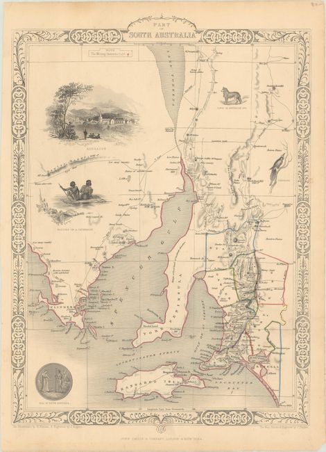
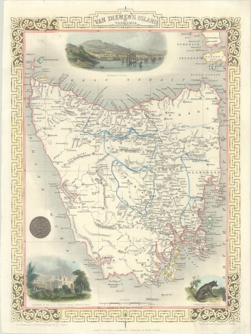
A nice pair of steel-engraved maps with decorative borders representing Tallis' view of southern Australia. The vignettes were drawn by H. Warren and engraved by J. Rogers, while the maps were drawn and engraved by J. Rapkin:
A. Part of South Australia. Finely engraved map featuring a large and well-rendered vignette city view of Adelaide, natives on a catamaran, and smaller vignettes of the state's seal, a dingo, and a tropical bird. The map details the region to include Adelaide, Kangaroo Island, York Peninsula, and Spencer Gulf. Mining districts are noted with hand coloring as given by small legend at upper left. Condition: Contemporary outline color on a lightly toned sheet. (B+)
B. Van Diemen's Island or Tasmania. This decorative steel-engraved map of the island features good detail of cities, rivers, boundaries, and topography. The map features three well-rendered vignettes showing Hobart, a Tasmanian Tiger (Thylacinus Cynocephalus, now extinct), and the residence of the V.D.L. Company's Agent, Circular Head Council. The V.D.L. (Van Diemen’s Land) Company was a large landholder in the north west corner of Tasmania. Condition: On a bright sheet with minor soiling. (A)
References: Tooley (Australia) #1231 & #1232.
Condition:
See description above.