Subject: United States & Mexico
Period: 1850-51 (circa)
Publication:
Color:
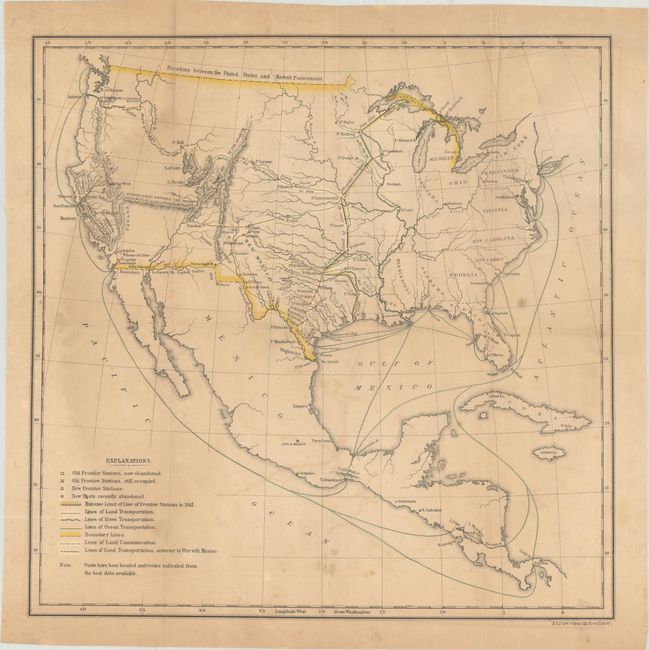
A. [Untitled - United States and Mexico], by U.S. Government, circa 1851, hand color (13.9 x 13.9"). This significant untitled map of the United States shows the new borders with Mexico and Canada and identifies army posts, old army posts, land transportation routes, and river/ocean transportation routes. A line from the mouth of the Sabine River in Louisiana north to Lake Superior indicates the "Extreme Limit of Line of Frontier Stations in 1845." Stations to the east of this line were primarily accessible by steamboat and railroads while stations to the west of the line were reached by wagon only. The famous "March of the Rifle Regiment in 1849" from Ft. Leavenworth to the Columbia River is also depicted. Wheat quotes the Cross' original report stating "The accompanying map will show more clearly than any written statement possibly can, the great difference between the country occupied by the troops on the 30th of June, 1845, and at the present time." Reference: Wheat (TMW) #727. Condition: Issued folding with light toning, dampstaining at left, and some minor foxing and offsetting. (B)
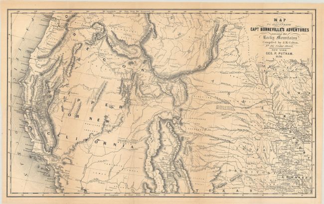
B. Map to Illustrate Capt. Bonneville's Adventures Among the Rocky Mountains, by Putnam/Colton, dated 1850, black & white (18.2 x 11.1"). This interesting map is based on Fremont's map. The region west of the Mississippi to the Pacific Ocean is delineated with the rivers and towns of the gold region in California well depicted. The expedition route described is that of Captain Benjamin Bonneville who explored the American West from 1832-1836. The expedition party traveled parallel to the course of the Snake and the Columbia Rivers, going as far as Fort Walla Walla before turning back. Fremont's route through California is shown, as well as Kearny's route along the Gila River and the Emigrant route. Reference: Wagner-Camp #67:14, cf. Wheat (TMW) #424. Condition: Issued folding with light toning along the fold lines and a 3" fold separation at bottom that has been closed on verso with archival tape. (B+)
References:
Condition:
See description above.