Subject: Lake Superior, Michigan
Period: 1849 (published)
Publication: H.R. Doc. 5, 31st Congress, 1st Session
Color: Hand Color
Size:
5.8 x 9.1 inches
14.7 x 23.1 cm
This is Charles T. Jackson's 565-page report examining the mineral lands of Michigan. The volume is profusely illustrated with 19 plates, 4 woodcuts, and the following four geological maps in hand color:
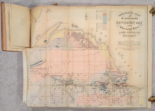
A. Geological Map of the District Between Keweenaw Bay and Chocolate River. Lake Superior Michigan (24.4 x 19.6"). This detailed geological map covers the region from the Keweenaw Bay to the Chocolate River. A color-coded key locates seven geological types, including sandstone, quartz, limestone, schistose and trappean rocks, granite and basalt. There is also good detail of relief shown in hachure. A scale below the title converts chains to miles. Fancy title lettering.
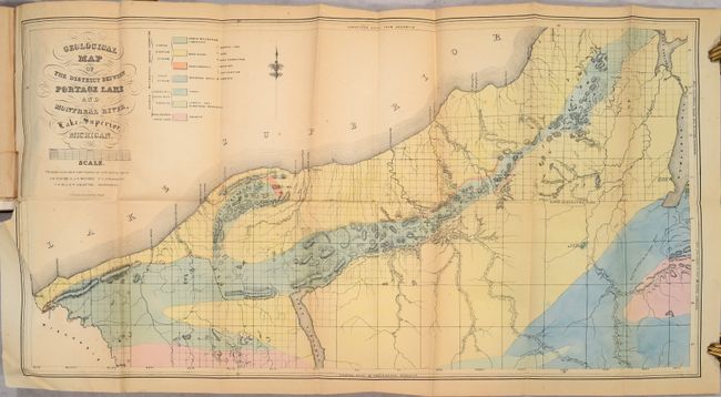
B. Geological Map of the District Between Portage Lake and Montreal River, Lake Superior, Michigan (29.6 x 15.4"). Covers the area from the Michigan/Wisconsin border to Keweenaw Bay with a color-coded key locating seven geological types. Locates both a Catholic and Methodist mission along Keweenaw Bay with several trails extending into the unsurveyed interior.
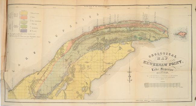
C. Geological Map of Keweenaw Point, Lake Superior Michigan (20.5 x 10.6"). This is a very detailed geological map that covers the region from Portage Lake to the tip of the point and also shows Manitou Island. A color-coded key locates geological units including sandstone, conglomerate, trap and jasper. The legend locates minerals, active and abandoned mines, and furnaces.
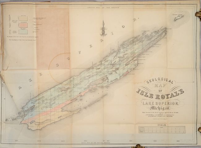
D. Geological Map of Isle Royale Lake Superior, Michigan (24.8 x 17.5"). This early geological map updates Jackson's map of 1847 and was completed after J.W. Foster and J.D. Whitney took over the Survey of the Mineral Lands of Michigan in 1850. It locates Sandstone, Conglomerate and "Trap: Basalt, Porphyry" with three different colors. Legend keys Mines, Abandoned Mines, Mineral Land Supposed to Contain Copper, Furnace, and more.
Hardbound in full contemporary leather with title label on spine.
References: Karpinski (MI) #758b, 764, 766 & 767; Marcou & Marcou #365, 366 & 369.
Condition: B
The folding maps have some light toning and offsetting, as well as minor foxing. The Isle Royale map also has a couple of light dampstains in the image. Text and other plates have light toning and scattered foxing. The hinges are starting and the binding is worn and stained.