Subject: Nantucket, Massachusetts
Period: 1864 (dated)
Publication:
Color: Hand Color
Size:
19 x 23.2 inches
48.3 x 58.9 cm
The Office of Coast Survey is the oldest U.S. scientific organization, dating from 1807 when Congress directed that a "survey of the coast" be carried out. By 1836, it was called the U.S. Coast Survey and in 1878, the name was changed to the U.S. Coast and Geodetic Survey. Today the Office of Coast Survey is a division of the National Oceanic and Atmospheric Administration NOAA.
The survey teams, composed of civilians as well as Army and Naval officers, charted the nation's waterways and produced a wide array of reports, survey charts, hydrographic studies of tides and currents, astronomical studies and observations, and coastal pilots. These charts are an important record of the changing nature of the nation's coastlines. In additional to coastal charts, the U.S. Coast and Geodetic Survey produced land sketches, Civil War battle maps, and the early aeronautical charts.
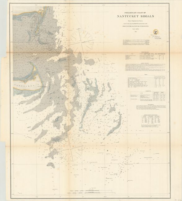
A detailed chart of Nantucket and Nantucket Shoals with numerous soundings, bottom types, lighthouses, and shoals. Tables at right include additional details on lighthouses, tides, currents, and more. Nantucket Shoals is a particularly dangerous area for vessels with water depths as little as 3 feet and highly unpredictable due to strong currents in the area.
References:
Condition: B
Issued folding and now flattened and backed with tissue. There is light toning along the fold lines and scattered foxing.