Subject: Cape Cod, Massachusetts
Period: 1857 (dated)
Publication:
Color: Black & White
Size:
17.3 x 14.7 inches
43.9 x 37.3 cm
The Office of Coast Survey is the oldest U.S. scientific organization, dating from 1807 when Congress directed that a "survey of the coast" be carried out. By 1836, it was called the U.S. Coast Survey and in 1878, the name was changed to the U.S. Coast and Geodetic Survey. Today the Office of Coast Survey is a division of the National Oceanic and Atmospheric Administration NOAA.
The survey teams, composed of civilians as well as Army and Naval officers, charted the nation's waterways and produced a wide array of reports, survey charts, hydrographic studies of tides and currents, astronomical studies and observations, and coastal pilots. These charts are an important record of the changing nature of the nation's coastlines. In additional to coastal charts, the U.S. Coast and Geodetic Survey produced land sketches, Civil War battle maps, and the early aeronautical charts.
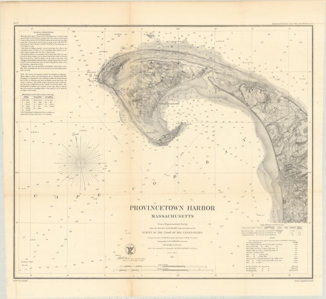
This detailed sea chart graphically depicts the tip of Cape Cod with soundings, magnetic variation, and the approach to anchor at Provincetown. The sailing directions at top left describe navigational hazards and a table beneath it presents the sea bottom types. A table at bottom right locates lighthouses and gives the heights of tides during the various times of year. Includes some inland detail of roads and buildings, including the Provincetown Town Hall.
References:
Condition: B+
Issued folding and now flattened and backed with tissue. There is light toning along the fold lines.