Subject: Dakota Territory
Period: 1874 (dated)
Publication:
Color: Black & White
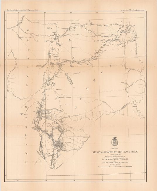
A. Map of a Reconnaissance of the Black Hills, July and August, 1874, with Troops Under Command of Lt. Col. G.A. Custer, 7th Cavalry, (21.4 x 25.5"). This is Ludlow's principle map that shows the entirety of Custer's reconnaissance of 1874. The map extends from Old Ft. Pierre on the Missouri River to the Little Missouri Buttes and north to the Badlands and the Yellowstone River. The map traces Custer's route through the region of the Black Hills with the date of each encampment. It contains many interesting notations, such as "Where they killed the Rees," "Where the sickman was killed" plus many comments on water, grasslands, springs, etc. The topography is nicely developed and portions of Raynold's 1859 route is shown. Condition: Issued folding with light toning along the folds, minor foxing, and a couple of short splits at the fold junctions.
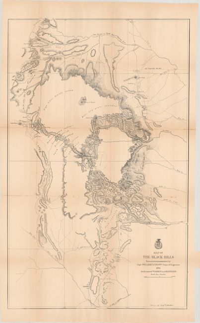
B. Map of the Black Hills from a Reconnaissance, (23.6 x 38.3"). A large map drawn by Sergeant C. Becker with additional geography from the maps of Warren and Raynolds. It covers the Black Hills between the Belle Fourche or North Fork of the Cheyenne River to the South Fork of the Cheyenne. Drawn on a scale of 3 miles=1 inch. Topography is nicely developed with portions of Warren's route of 1857 and that of Raynold's in 1859 shown. Condition: Issued folding with light toning, minor foxing, and several small fold separations along an upper horizontal fold.
References:
Condition: B+
See description above.