Subject: World
Period: 1739 (published)
Publication: Modern History: or, the Present State of all Nations
Color: Hand Color
Size:
20.2 x 7.3 inches
51.3 x 18.5 cm
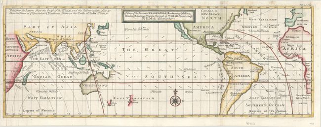
This chart describes the world between about 50° north and south latitude. This includes southern Newfoundland to just north of Tierra del Fuego. The chart shows nearly blank continents with just country names and little else. Its main focus is an extremely detailed view of sea-borne winds. The legend explains the lines and arrows used to delineate the winds, with the abbreviated months indicating the times of year for monsoons. Largely based on the work of the English scientist Sir Edmund Halley. Published in London in Thomas Salmon's Modern History: or the Present State of All Nations. This is an early edition of this map, which was re-engraved for later editions of Salmon's work with a slightly different title.
References: McCorkle (18th C. Geography Books) #347, Vol. III [3].
Condition: B+
A crisp impression on a bright sheet, issued folding with professional repairs to several short edge tears and a long tear along the left border.