Subject: Eastern United States
Period: 1810 (dated)
Publication: Travels on an Inland Voyage...
Color: Black & White
Size:
18.6 x 16.4 inches
47.2 x 41.7 cm
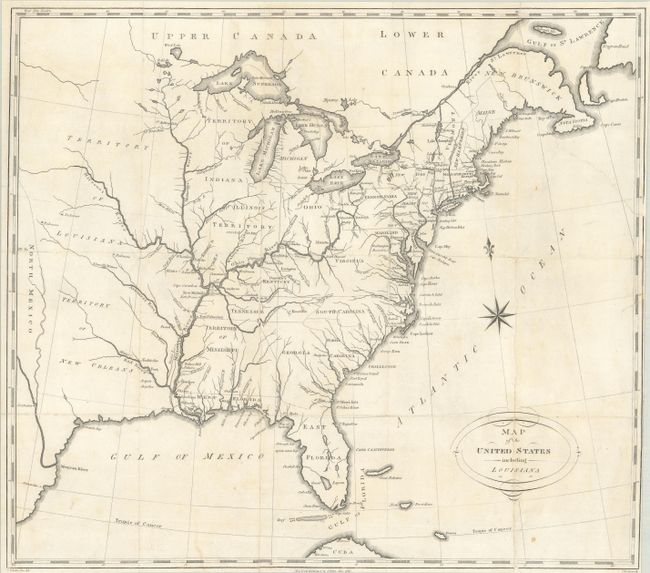
This is the largest of five maps included in Christian Schultz's Travels on an Inland Voyage Through the States of New-York, Pennsylvania, Virginia, Ohio, Kentucky and Tennessee.... The book describes Schultz's inland journey from New York state to New Orleans via the Ohio and Mississippi rivers, and is notable for giving an accurate and detailed account of the frontier. Howes describes the account as the "best description of this region at the period."
Cartographically, the map extends beyond the Mississippi River to past the 100th meridian. It depicts a large Mississippi Territory occupying present-day Alabama and Mississippi, with a huge Territory of New Orleans to its immediate west. North of the Arkansas River is the Territory of Louisiana. Florida is divided between East & West. The map locates numerous forts and mines along the Ohio and Mississippi rivers.
There are two interesting anomalies in the map: the names for North and South Carolina are reversed, and Indiana Territory is shown to the northwest of Illinois Territory. Other examples, apparently published later in the same year, have corrected the labeling issue in the Carolinas and renamed Indiana Territory to Northwest Territory. Drawn by Schultz, engraved by I. Scoles, and published in New York by Isaac Riley. This example is backed in linen.
References: Howes #S-202; Sabin #78003.
Condition: B
Issued folding, now flat and backed with linen, with numerous fold separations and a 4" edge tear at right that have been professionally conserved. Trimmed close to the right border and light soiling.