Subject: Eastern United States
Period: 1795-1822 (circa)
Publication:
Color:
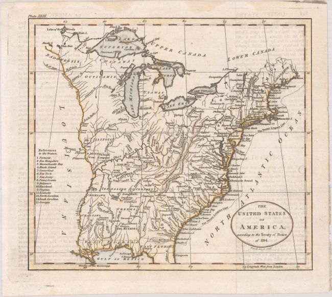
A. The United States of America, According to the Treaty of Peace of 1784, by William Guthrie, from A New Geographical, Historical, and Commercial Grammar..., circa 1795, hand color (8.1 x 7.3"). This early map depicts the young United States following the ratification of the Treaty of Paris. It details the fledgling states and the Indian lands east of the Mississippi River. The region west of the Mississippi River is completely blank with no features, but good detail is provided along its eastern side locating several named Indian villages and Revolutionary War bounty land grants including those of the Illinois Company, New Jersey Company, and Wabash Company. Several Army Lands are located in both Kentucky (unnamed) and in the Tennessee Government. Tennessee had recently split from western North Carolina and would soon gain statehood. Ohio is a small area labeled Ohio Company and Donation Lands with no sign of the other bounty grants named on Russell's larger, derivative map. The area northeast of the upper Mississippi River is largely unorganized with a few rivers, forts, and settlements. The map locates Detroit, the Lake of the Woods, and Upper and Lower Iowa in this region. In the far northeast the territory of Sagahadok is a large region above the barely mentioned Main. In the south, the northern portion of Florida is depicted and divided into East Florida and West Florida. At the conclusion of the war, control of Florida was returned to Spain in gratitude for their neutrality during the American Revolutionary War. Georgia is listed at the fifteenth state and appears to extend to the Mississippi River. There is good detail of the river systems, towns and villages, forts, Indian lands, and more. The Twenty Leagues Line is drawn in the Atlantic. The title misdates the Treaty of Paris to 1784, instead of 1783. Engraved by John Russell. This map was published in the 1795, 1796, and 1798 editions of Guthrie's Grammar. References: McCorkle #795.11; McCorkle (18th C. Geography Books) #172-22. Condition: Issued folding with light offsetting from an opposing page of text, a few spots of foxing, and faint dampstains in the upper margin.
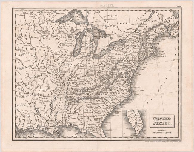
B. United States, by Russell & Sons, circa 1822, black & white (9.6 x 7.5"). This small, but intricately detailed map of the United States was drawn and engraved by Russell & Sons in Penge, near Sydenham, Kent. It shows the first 24 states, including the new addition of Missouri. Arkansas is still a territory, here stretching from the Mississippi west into present-day Oklahoma. Texas is named. Michigan Territory is identified. To its west is the North West Territory, which is comprised of the Upper Peninsula, Wisconsin, and part of Minnesota. A vast Western Territory includes parts of present-day Minnesota, Iowa, Nebraska, and the Dakotas. Florida's southern tip is depicted in a small inset. Condition: A nice impression with light offsetting.
References:
Condition: B+
See description above.