Subject: United States
Period: 1960 (circa)
Publication:
Color: Printed Color
Size:
33.8 x 23.8 inches
85.9 x 60.5 cm
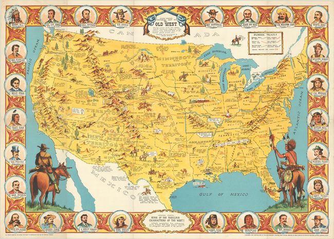
This pictorial map of the United States shows the progression of western migration from about 1840-1900 with an emphasis on Indian conflicts and well-known individuals. It is densely filled with illustrations and notations of key events including: "Buffalo Bill Supplied Meat for Railroad Gangs in 1858"; "March 6, 1836 The Alamo Mission Falls to Mexicans. Col. Jim Bowie and Davy Crockett Among Those Killed!"; and "Custer's Last Stand Sioux and Cheyenne Under Crazy Horse and Sitting Bull June 25, 1876." A key at top identifies "Pioneer Trails" including the Oregon, Santa Fe, and Chisholm Cattle Trail, as well as the Pony Express Route and Union Pacific Railroad. The decorative border surrounding the map is filled with "Some of the Fabulous Characters of the West" including Jesse James, Wyatt Earp, Kit Carson, Wild Bill Hickok, and Annie Oakley to name a few. Created by Fran Dowie and published by the Old Western Trading Post Limited of London.
References:
Condition: A
A bright example, issued folding with a few tiny separations at fold intersections and some pinholes along the edges of the sheet, not affecting the image.