Subject: Western Hemisphere - America
Period: 1809 (dated)
Publication:
Color: Hand Color
Size:
30.2 x 20.5 inches
76.7 x 52.1 cm
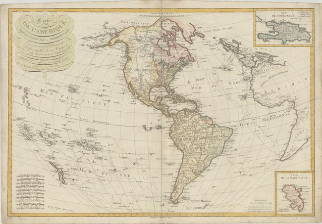
This very scarce copper-engraved map of the Western Hemisphere showcases the discoveries of Cook, Mackenzie, and Vancouver, delineating the tracks of Cook's voyages. Based on the cartography of Rigobert Bonne, this map is a corrected and updated version of a large map first published by Basset in 1795. It extends in the west to include New Zealand and the many islands of the South Pacific and in the east to cover Western Europe and the western coast of Africa. There is nice topographical detail, and several Indian tribes and towns and cities are named in the Americas. Despite the 1809 date, the colorist inaccurately shows the United States confined to the area east of the Appalachians, with the area between the United States and the Mississippi River depicted as a French-controlled region. A large Spanish Lousiana Territory appears west of the Mississippi, and present-day Texas, California, and the rest of the American Southwest are still under Spanish control. The Arctic passage of Cluny in 1768 is delineated. There are two insets at right: Isle de St. Domingue and Isle de la Martinique. The title is in decorative lettering at top left. Ten distance scales fill the bottom left corner.
References:
Condition: B+
There is light soiling and a few small tears and separations along the centerfold that have been repaired with archival materials on verso.