Subject: South Pacific Ocean
Period: 1773 (published)
Publication: Account of the Voyages Undertaken...in the Southern Hemisphere
Color: Black & White
Size:
26.8 x 14.2 inches
68.1 x 36.1 cm
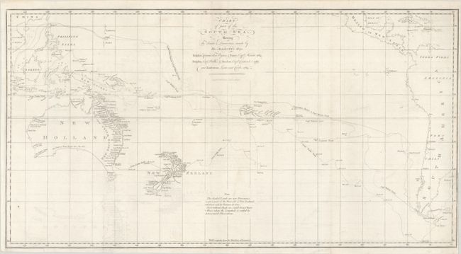
Captain James Cook (1728-1779) is best known for his three voyages to the Pacific (1768-71; 1772-75; and 1776-79). His discoveries radically changed the western understanding of the world in the late 18th century. He was the first to circumnavigate and chart New Zealand and provided the earliest European accounts of exploration along the eastern coast of Australia and the Hawaiian Islands. On February 14th, 1779, he was killed on Hawaii after attempting to kidnap the chief of the island.
Many contemporary accounts of Cook’s voyages, including charts and engravings, appeared in the late 18th century. The first official account of Cook’s first voyage was published in 1773 by John Hawkesworth in Volumes II and III of An Account of the Voyages Undertaken by the Order of His Present Majesty for Making Discoveries in the Southern Hemisphere... William Strahan and Thomas Cadell published the first official accounts of the second and third voyages in 1777 and 1784. Accounts of his exploration were subsequently translated into French, German, and Dutch.
This chart of the South Pacific covers the region from Australia and Southeastern Asia to the western coast of South America, and is filled with the tracks of the explorers Cook, Byron, Wallis, and Cateret. Lands that are shaded indicate new discoveries by these parties and include eastern Australia, most of New Zealand, portions of New Guinea, and the Society Islands. Cook's new place names appear along the eastern coast of Australia including Botany Bay, C. Banks, and Pt. Solander. Engraved by W. Whitchurch and published by John Hawkesworth in his Account of the Voyages Undertaken...in the Southern Hemisphere.
References: Tooley (Australia) #321; Shirley (BL Atlases) G.HAWK-1a #1.
Condition: B+
A bright sheet, issued folding with light offsetting and minor soiling. There is a binding trim at right close to the neatline, with two adjacent binding tears that just enter the map border and have been closed on verso with archival tape.