Subject: Philippines
Period: 1748 (circa)
Publication: A Voyage Round the World…
Color: Black & White
Size:
21.1 x 27.5 inches
53.6 x 69.9 cm
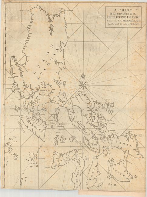
Anson's chart of the Philippine Islands spans from Luzon to Leyte. The focus of the chart is on the track of the Manila Galleon from the Mole of Cabite until it is clear of land, north of Samal. The chart was beautifully engraved by Richard William Seale with rhumb lines and a large compass rose.
In 1740 Anson set sail in command of a squadron sent to attack Spanish possessions and interests in South America. The expedition was ill-equipped and failed to carry out its original ambitious mission. By June 1741, when Anson reached Juan Fernandes, his force had been reduced to only three of the original six ships, while the strength of his crews had fallen from 961 to 335. After recuperating on the island, he collected the remaining survivors on his flagship, the Centurion, and set sail in search of one of the richly laden galleons that conducted the trade between Mexico and the Philippines. The indomitable perseverance he had shown during one of the most arduous voyages the history of sea adventure gained the reward of the capture of an immensely rich prize, the Nuestra Señora de Cabadonga, a Spanish treasure galleon he encountered off Cape Espiritu Santo on June 20, 1743.
References: Mercator's World (Nov/Dec 1998) p. 47; Shirley (BL Atlases) G.ANS-1a #8.
Condition: B
Issued folding with scattered foxing. There is a binding trim at bottom that has been partially replaced with old paper, with an associated tear that extends 1" into map image along with some minor extraneous creasing along the bottom edge.