Subject: Asia
Period: 1700 (circa)
Publication:
Color: Hand Color
Size:
23.4 x 19.8 inches
59.4 x 50.3 cm
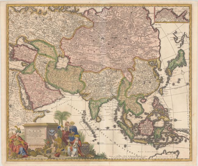
This large, beautifully engraved map of Asia is particularly significant for its depiction of Russia, Siberia, and parts of Chinese Tartary. The information on this region was taken from Nicolas Witsen's 6-sheet map of Tartary from 1687 as noted above the bottom border. Witsen gathered much of this information from the governor of Tobolsk, and formulated a completely new interpretation of the northeast extremity of the continent, shown here in an inset. It shows a long mountainous peninsula, Ys Caap (Icy Cape), which was believed to render it impossible to sail around northern Asia to reach the wealth of the East Indies. A strangely shaped and partially delineated Hokkaido appears just north of Japan, with Comp.es Landt stretching off the edge of the map. Witsen's influential map became the standard model for the mapping of Asia until the expeditions of Bering (1725-1749). The rest of the map draws mainly on De Wit's maps of Asia, except that Allard presents a completely different, and apparently unique, configuration of the Black and Caspian Seas. The fabulous title cartouche features the personification of Asia receiving tribute from a number of her subjects.
References: Tibbetts #173; Yeo #70.
Condition: B+
A nice impression with full contemporary color with minor toning and archival repairs to some small tears and chips along the edges of the sheet. There is an old stamp on verso from the former Bibliotheca Provincia Argentor of the Congregatio Sanctissimi Redemptoris (Congregation of the Most Holy Redeemer).