Subject: Eastern Mediterranean & Middle East
Period: 1716 (published)
Publication:
Color: Hand Color
Size:
18.8 x 14.2 inches
47.8 x 36.1 cm
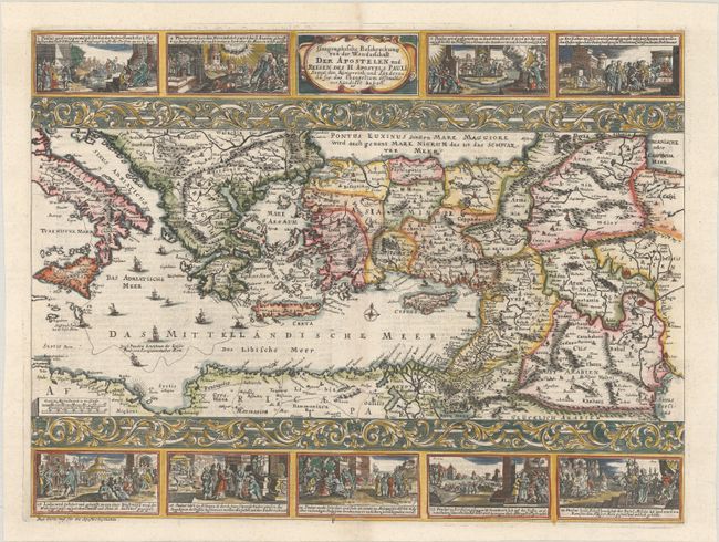
This rare map is a close copy of Nicolas Visscher's map, Geographische Beschryvinghe van de Wandeling der Apostelen ende de Reysen Pauli, first published circa 1657. The map portrays the eastern Mediterranean from Rome, through Asia Minor and the Holy Land, to Babylon. Territorial divisions reflect the political conditions of the first century A.D. The route of Apostle Paul is charted from Jerusalem to Rome. The decorative panels at top and bottom were also copied from Visscher's map (who had copied them from his father's map), however in this edition each vignette is a mirror image. They show the major events of Paul's journey; each vignette being a composite of two or three episodes. The one at the left of the cartouche shows Paul blinded on the road to Damascus, his baptism by Ananias, and finally his daring escape from the city. Other scenes depict the young Paul before his conversion, healing the paralytic, his ship wreck at Malta, and his appearance before Nero. The engraver has also added lovely decorative panels separating the vignettes from the map, which do not appear on Visscher's map. This rare map was published in a German bible by Johann Detleffsen in Minden. German text on verso.
References:
Condition: A+
A dark impression on a bright sheet.