Subject: France
Period: 1800 (circa)
Publication:
Color: Hand Color
Size:
40.9 x 24 inches
103.9 x 61 cm
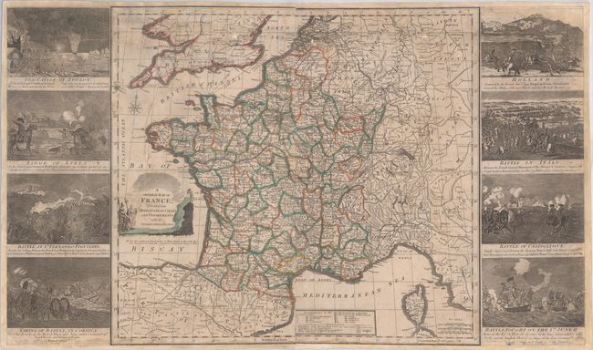
This rare and impressive map of France was published during the French Revolutionary Wars. At its center is a large map of the country that identifies political divisions, towns and cities, roads, rivers, and more. It extends to include parts of neighboring countries. A key at bottom features more information about the metropolitan circles. Allegorical figures in the title cartouche reference the concept of "liberté, égalité, fraternité" at the center of the French Revolution. The map is flanked by eight dramatic vignettes commemorating key events and battles from the French Revolutionary Wars: Evacuation of Toulon; Siege of Ypres; Battle at St. Fernando Figuieres; Taking of Bastia, in Corsica; Holland; Battle in Italy; Battle of Castiglione; and Battle Fought on the 1st June 17[94] (the so-called Glorious First of June).
References:
Condition: B
The map has been backed on heavy linen, closing several chips and tears throughout the map image. There are light stains and soiling, and some small areas of loss to map image, most notably in the vignette at bottom right, which includes some facsimile work.