Subject: Britain
Period: 1647 (circa)
Publication: Toonneel des Aerdrycks oft Nieuwe Atlas...Vierde Deel
Color: Hand Color
Size:
19.8 x 15.3 inches
50.3 x 38.9 cm
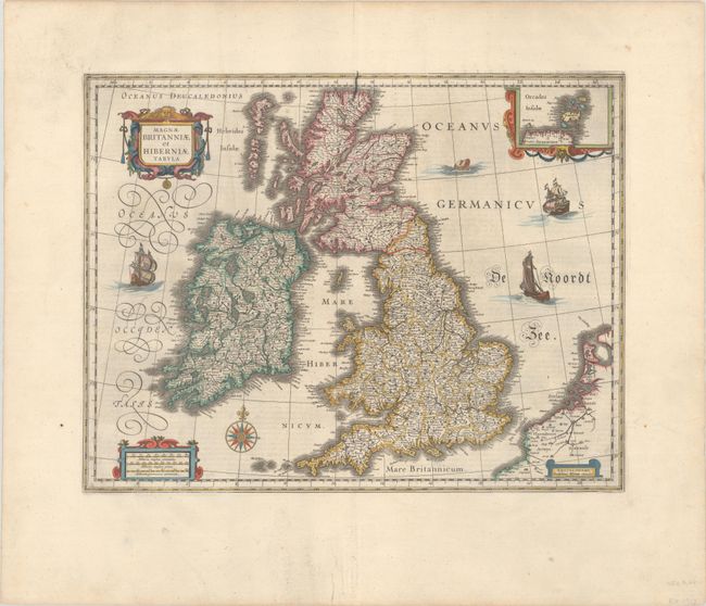
This handsome map of the British Isles is believed to be printed from the revised plate of Hondius' carte-a-figures map of 1630. Blaeu acquired a number of Jodocus Hondius' plates from Hondius' widow in 1629. As this map was too large to fit in Blaeu's atlas, it is presumed that he removed the surrounding panels. It is filled with minutely engraved topographical and political detail of England, Wales, Ireland and Scotland, and is inset with a small map of the Orkney Islands. The map appeared in many of the Blaeu atlases between 1634 and 1672 and was included in all editions of the Blaeu atlas of England and Wales from 1645 onwards. It is decorated with a lovely compass rose, and a decorative scale of miles and title cartouche. Three delicately engraved ships and a large sea monster complete the composition. Dutch text on verso, published 1647-62. There is a crack in the plate that is visible at top center.
References: Moreland & Bannister, p. 217; Shirley (BI to 1650) #423; Van der Krogt (Vol. II) #5000:2.2.
Condition: A
A crisp impression with full contemporary color on a bright sheet with the watermark of the god Atlas. There is minor toning and soiling in the very wide margins, a soft vertical crease, and a short, archivally repaired tear in the bottom margin.