Subject: Tierra del Fuego
Period: 1773-84 (circa)
Publication:
Color: Black & White
Captain James Cook (1728-1779) is best known for his three voyages to the Pacific (1768-71; 1772-75; and 1776-79). His discoveries radically changed the western understanding of the world in the late 18th century. He was the first to circumnavigate and chart New Zealand and provided the earliest European accounts of exploration along the eastern coast of Australia and the Hawaiian Islands. On February 14th, 1779, he was killed on Hawaii after attempting to kidnap the chief of the island.
Many contemporary accounts of Cook’s voyages, including charts and engravings, appeared in the late 18th century. The first official account of Cook’s first voyage was published in 1773 by John Hawkesworth in Volumes II and III of An Account of the Voyages Undertaken by the Order of His Present Majesty for Making Discoveries in the Southern Hemisphere... William Strahan and Thomas Cadell published the first official accounts of the second and third voyages in 1777 and 1784. Accounts of his exploration were subsequently translated into French, German, and Dutch.
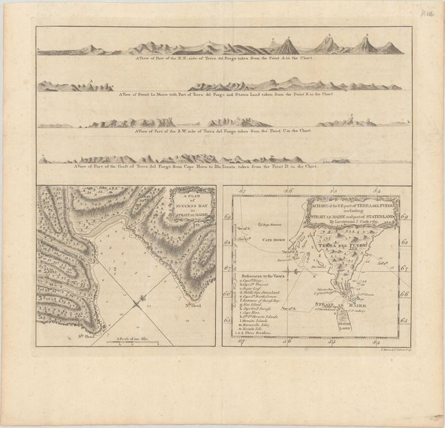
A. A Plan of Success Bay in Strait Le Maire [on sheet with] A Chart of the S.E. Part of Terra del Fuego Including Strait Le Maire and Part of Staten-Land by Lieutenant J. Cook 1769, by Thomas Bowen & John Gibson, circa 1773 (14.2 x 12.1"). This sheet contains two charts in the lower half beneath four coastal perspectives. The Tierra del Fuego chart (at bottom right) depicts the tract of the Endeavor as Capt. Cook traveled from east to west between January 11th - 27th, 1769. A lettered reference locates and names 14 places on the views above. The plan of Success Bay (at bottom left) shows great detail including soundings, anchorage, and a compass rose and features a surprising amount of inland detail. Both charts have their own border and decorative rococo-style title cartouche. The four view perspectives illustrate Tierra del Fuego and Cape Horn from various angles. This early Cook exploration map is from his first voyage. Engraved by Bowen & Gibson for Hawkesworth's An Account of the Voyages Undertaken by the Order of His Present Majesty.... Reference: Shirley (BL Atlases) G.HAWK-1a #17. Condition: Issued folding on paper with a Strasburg bend & lily watermark, minor soiling, and a small separation at the fold intersection.
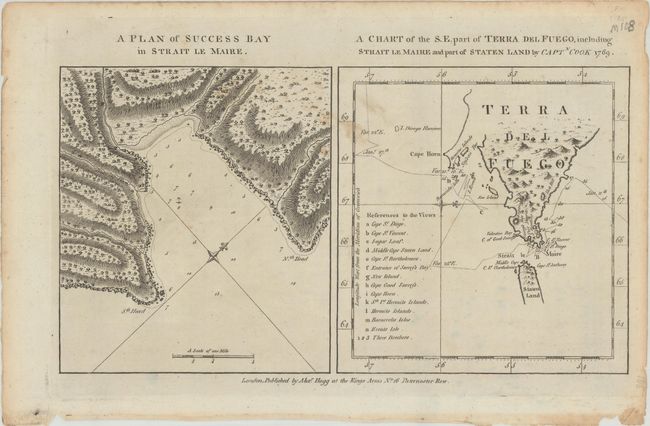
B. A Plan of Success Bay in Strait Le Maire [on sheet with] A Chart of the S.E. Part of Terra del Fuego, Including Strait Le Maire and Part of Staten Land by Captn. Cook 1769, by Alexander Hogg, circa 1784 (13.4 x 7.2"). This sheet includes the same two maps, newly engraved for George Anderson's A New, Authentic and Complete Collection of Voyages Round the World, without any coastal perspectives. References: Shirley (BL Atlases) G. AND-1a #13. Condition: A crisp impression with a few small stains in the image and light toning and small chips along the edges of the sheet.
References:
Condition: B+
See description above.