Catalog Archive
Auction 185, Lot 346

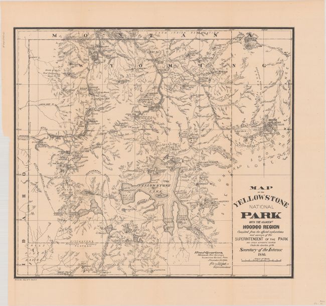
"[Map with Report] Map of the Yellowstone National Park with the Adjacent Hoodoo Region... [with] Annual Report of the Superintendent of the Yellowstone National Park", U.S. Department of Interior

Subject: Yellowstone, Wyoming

Period: 1880 (published)

Publication:

Color: Black & White

Size:
17.5 x 15.8 inches
44.5 x 40.1 cm
Download High Resolution Image
(or just click on image to launch the Zoom viewer)

This map is roughly centered on Yellowstone Lake and shows the "Hoodoo" or Goblin Mountain to the east of the park. This area was given its name for the giant rocks that jut up to 60 feet in the air and have a ghostly appearance. Shows the "Route of Exploration" from the Indian Lodges just outside of the eastern park boundary to the Hot Springs. The map is accompanied by the 68-page annual report with 3 single-page plates and an attractive folding view of Mammoth Hot Springs (11.5 x 6.4"). The disbound report is housed in archival paper covers with handwritten label.

References:

Condition: A

Folding map is near fine with a hint of pleasant toning. Disbound text is very good with a small chip in the top right blank margin of the first 43 pages.

Estimate: $160 - $190

Sold for: $240

Closed on 11/17/2021

Archived