Subject: Texas, Gulf Coast
Period: 1842-67 (dated)
Publication:
Color: Black & White
The Office of Coast Survey is the oldest U.S. scientific organization, dating from 1807 when Congress directed that a "survey of the coast" be carried out. By 1836, it was called the U.S. Coast Survey and in 1878, the name was changed to the U.S. Coast and Geodetic Survey. Today the Office of Coast Survey is a division of the National Oceanic and Atmospheric Administration NOAA.
The survey teams, composed of civilians as well as Army and Naval officers, charted the nation's waterways and produced a wide array of reports, survey charts, hydrographic studies of tides and currents, astronomical studies and observations, and coastal pilots. These charts are an important record of the changing nature of the nation's coastlines. In additional to coastal charts, the U.S. Coast and Geodetic Survey produced land sketches, Civil War battle maps, and the early aeronautical charts.
Nine early Coast Survey charts showing the development of the Texas Gulf Coast in the latter part of the 19th century. All are encased in Mylar for preservation:
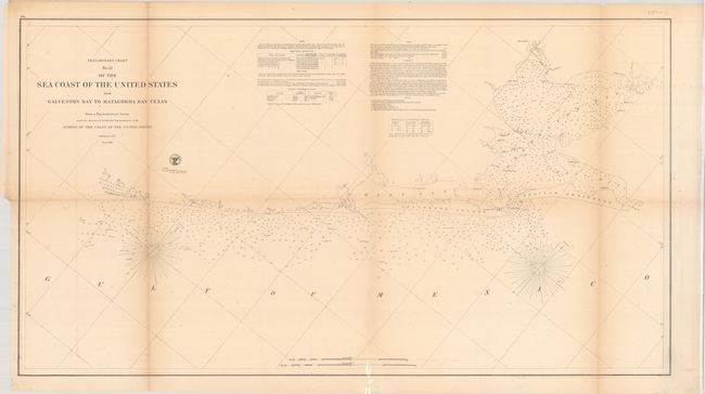
A. Preliminary Chart No. 31 of the Sea Coast of the United States from Galveston Bay to Matagorda Bay Texas..., dated 1857 (36.5 x 20.0"). A detailed chart of the region including numerous soundings, bottom types, magnetic variation, and detailed navigational notes. Condition: Lightly toned, primarily along the folds, with minor offsetting and short splits along the folds. (B+)
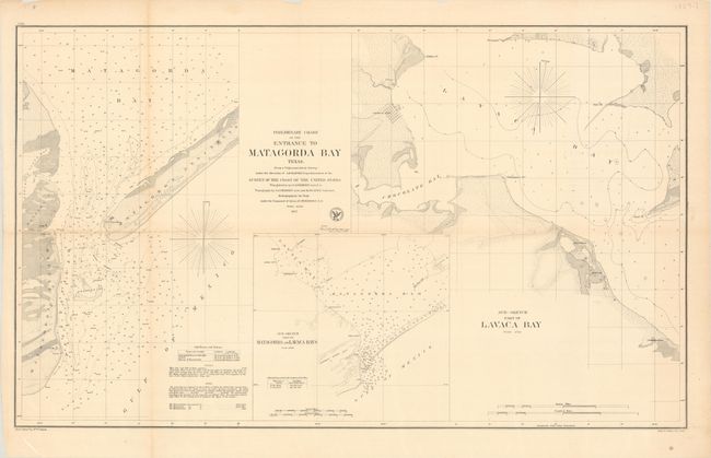
B. Preliminary Chart of the Entrance to Matagorda Bay Texas..., dated 1857 (32.5 x 19.4"). Three charts on one sheet. The primary chart features numerous soundings in Matagorda Bay with good coastal detail of Matagorda Island and Matagorda Peninsula. The other two charts depict Lavaca, Chocolate, and Matagorda bays. Condition: A few splits at fold intersections and a touch of toning along the fold at left. (A)
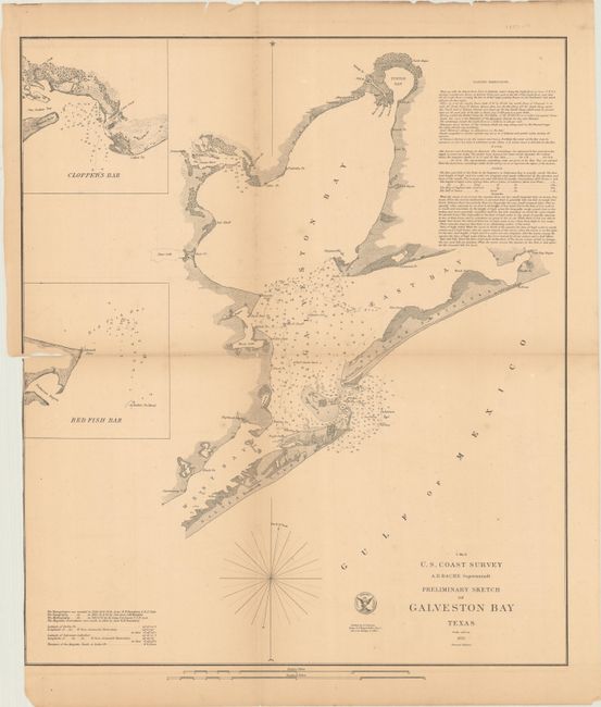
C. Preliminary Sketch of Galveston Bay Texas, dated 1852 (16.8 x 19.3"). The second edition of this handsome coastal chart shows the entire Galveston Bay with the city located at its entrance on Galveston Island. Includes insets of Clopper's Bar and Red Fish Bar. Extensive sailing instructions and the seal of the U.S. Coast Survey complete the chart. Condition: On a toned sheet with some splits along the folds, including a 2" tear at left. The margin has been trimmed at bottom left, with a sliver of the neatline missing. (B)
D. Galveston Entrance Texas, dated 1867 (18.6 x 15.7"). This chart teems with navigational information related to the entrance to Galveston Bay, including soundings, bottom types, tides, buoys, lighthouses, or more. It shows Galveston in plan form, as well as Pelican Island and Bolivar Point. Condition: On a toned sheet with a light stain near the center and some splits along the folds, including a long 12" separation. A couple smaller splits have been closed with tape on verso. (B)
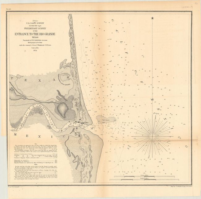
E. Preliminary Survey of the Entrance to the Rio Grande Texas, dated 1854 (14.5 x 13.6"). This represents the only USCS charting of the area. It provides a detailed view of the first few miles of this great river. At the mouth of the river is the village of Bagdad, and an observatory is located on the opposite shore. There is nice topographical detail and many soundings given, including in the Rio Grande itself. Drawn by W.E. Greenwell and engraved by C.A. Knight and F.W. Benner. Condition: There is light toning along the folds, some extraneous creasing, a few fold separations, and a binding trim at bottom left, with a small part of the neatline missing. (B+)
F. Reconnoissance of Sabine Pass..., dated 1853 (8.7 x 10.9"). This small chart depicts Sabine Pass, the boundary between the states of Texas and Louisiana. It is filled with numerous soundings, descriptions of the water's bottom, and sailing directions. Condition: Lightly toned with a tear in the top blank margin. (B+)
G. Reconnoissance of Aransas Pass Texas..., dated 1853 (9.1 x 12.3"). This small chart zooms in on the confluence of the Corpus Christi and Aransas bays and identifies Low, Mustang, and San Jose islands. Condition: On a toned sheet with some short fold separations. There is a binding trim at bottom left, with a portion of the border missing. (B)
H. Sketch I Showing the Progress of the Survey in Section No. 9 1848 to 55, dated 1855 (21.4 x 7.6"). Presents the surveying progress along the coast from Corpus Christi to Galveston. Condition: There is light toning along the folds. (B+)
I. Sketch of the Gulf of Mexico Showing Lines of Deep Sea Soundings and Profiles of Bottom, dated 1856 (27.8 x 15.0"). An interesting sheet showing a chart of the Gulf Coast with 15 different profiles showing the various depths of the Gulf's bottom. Condition: There is light toning along the folds and a few short splits. (B+)
References:
Condition:
See description above. All issued folding.