Subject: Mid-Atlantic United States
Period: 1794 (dated)
Publication:
Color: Hand Color
Size:
26.3 x 19.1 inches
66.8 x 48.5 cm
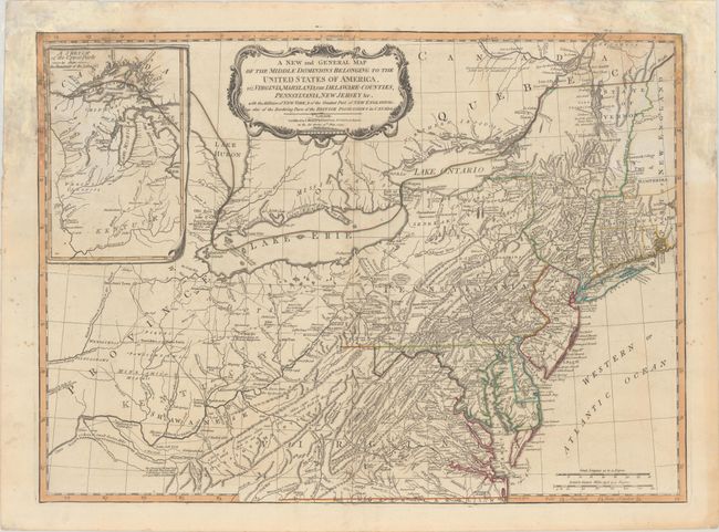
This is probably one of the most popular contemporary maps depicting the new United States. It is a derivative of the Lewis Evans map originally published by Thomas Kitchin in 1756. Evans' map contributed enormously to the cartographic knowledge of the Ohio Valley and was the first map to indicate the presence of petroleum in Pennsylvania and coal in Ohio, as well as denoting important passages through the Appalachians. Evans relied on the Fry/Jefferson map of Virginia and Maryland to depict the Virginia portion of his map, although he corrected the great bend in the Potomac River. The coastline from Chesapeake to Narragansett Bay is carefully delineated, and substantial detail appears westward as far as present-day Indiana. The large inset, A Sketch of the Upper Parts - to show the Remainder of the Lakes, focuses on the region of the Welinis or Illinois Indian nation, with Fort Detroit noted. The map is filled with fascinating notations. Originally issued by Thomas Kitchin in 1756, the plate went through numerous re-issues while passing through the possession of Thomas Jefferys, Sayer & Jefferys, Sayer & Bennett, and finally, Laurie & Whittle in 1794.
References: McCorkle #794.6; Tooley (Amer) p. 68, #30h; Stephenson & McKee, p. 53-54.
Condition: B
Contemporary outline color with dampstaining in the top corners of the sheet that has been backed with old paper on verso for reinforcement.