Subject: Eastern United States, Franklin
Period: 1819 (published)
Publication: A General Atlas…
Color: Hand Color
Size:
11.6 x 8.8 inches
29.5 x 22.4 cm
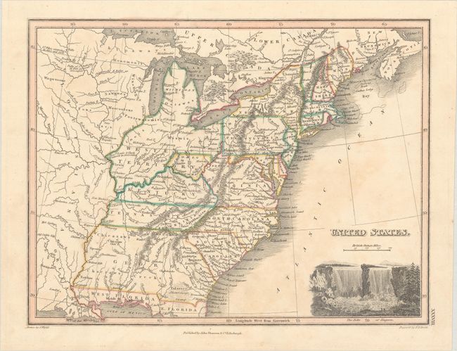
This is the first state of this small map of the young United States that includes several important historical regions. One of the most unique and scarce features on early maps of the United States is the appearance of Franklinia. In 1785 settlers in present-day western North Carolina and eastern Tennessee organized a state government to be named in honor of Benjamin Franklin. Congress turned down their appeal, but the fledgling state maintained a legislature and governor until 1788. This ephemeral state appeared on only a small number of maps into the early part of the 19th century, this being a late example. Another interesting feature is the region labeled Indiana that takes up what is now West Virginia. This land was a major contention between the private Indiana Land Company and the State of Virginia in the latter part of the 18th century. The argument over ownership of the property resulted in the Eleventh Amendment to the U.S. Constitution and the Indiana Land Company lost its claim to the land. Several other interesting place names include the Heckerton Settlement, many early forts, Indian villages, and the location of the winter camps for Lewis & Clark in 1803/04 and Lieut. Pike's two years later. The large Western Territory takes up present-day Michigan, Wisconsin, Illinois, Indiana, and part of Ohio. The large Louisiana is further west. Published by John Thomson in Edinburgh. Engraved by N.R. Hewitt.
References:
Condition: B+
Contemporary outline color with minor toning.